 Location:
 Length:
 Surface:
 Start / End:
 Suitable for:
The Bass Coast Rail Trail is 23km and extends from Woolamai (near Philip Island) to Wonthaggi, running near the South Gippsland coast for much of that distance. Besides cute towns like Kilcunda and Dalyston, it has an iconic beachside trestle bridge.

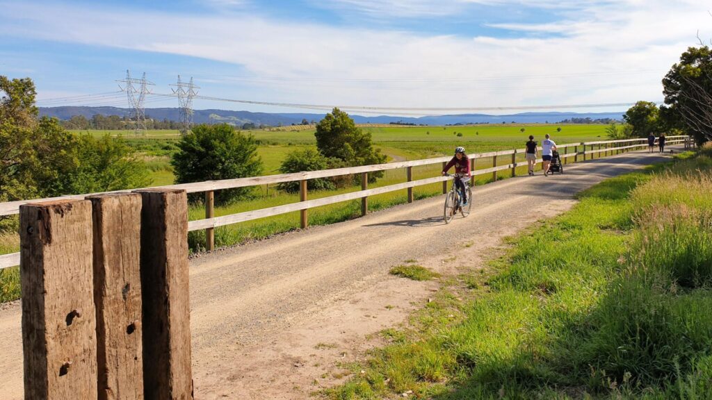
Experience sprawling farmland in a spectacular coastal setting with an interesting past. Breathe the clean sea air and watch ocean waves crashing on the rocks. Hear wild bird song and discover native animals. This trail offers a very different experience. The terrain is flat with just two moderate climbs, amazing views and an iconic timber bridge to cross. Some local buses are fitted with bike racks on the front to give an easy option for return trips between Wonthaggi and Anderson, and towns in between. See the “GET AROUND” section.
Nearby Attractions
- Phillip Island Nature Parks
- Railway Station Museum, Wonthaggi
- State Coal Mine Historic Reserve
- Bourne Creek trestle bridge at Kilcunda
- Powlett River wind turbines
- George Bass Coastal Walk
- East Area Trail from Wonthaggi
- Anderson to San Remo Shared Pathway
- Great Southern Rail Trail
Last updated: 12 November 2025
The trail starts with a bit of a whimper in Woolamai while local government struggles with the complexities of getting it 24km to the original junction near Nyora. The trail is predominantly crushed granite with 1km sealed at the Wonthaggi end.
Sand appears on the Kilcunda section when it is windy and the wooden bridges require care.
There are two main sections:
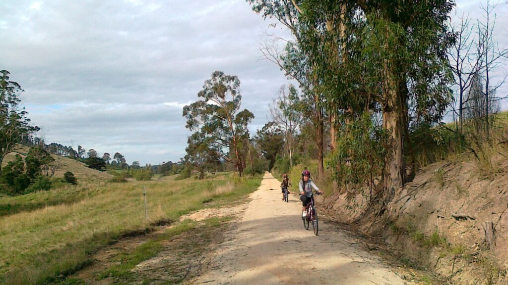
- Woolamai to Kilcunda (10km): This section is predominantly along the coast, with spectacular views and the small of sea spray in the air
- Kilcunda to Wonthaggi (13km): Once you see the coal mine you’ll understand why they built the challenging railway line.
Section Guides
Woolamai to Anderson (6km)
- Access: There’s no access to the station site at the racecourse. On-street parking is available in McGrath Rd, no facilities
- From McGrath Rd, you can see the old station platform mound where punters could alight to attend the races
- The trail travels through the small town and then slightly uphill through open farmland bordered by the coastal ranges. Melaleuca (tea tree) scrub lining the trail offers some wind protection
- The path is mainly flat as it skirts the hills, offering views of Western Port and Cape Woolamai on Phillip Island.
- Anderson is home to a roundabout and an art gallery.
Anderson to Kilcunda (4km)
- Access: The trail hub at Anderson is off the Bass Hwy roundabout to San Remo. It’s a great starting point with a large carpark, shelter, toilets, picnic tables and corral
- From Anderson, the trail winds around the hills offering magnificent views of the ocean, Kilcunda Surf Beach and Williamsons Beach
- You will pass the site of Mitchell’s Black Coal Mine at Mitchells Rise, where there is a walking track. The tailings heap has been fenced off
- Cross the Bass Hwy at the site of another trestle bridge and continue to the Kilcunda Foreshore Reserve
- Kilcunda is a reasonably large town with a café/general store, hotel and beachfront holiday park.
Kilcunda to Wonthaggi (13km)
- Access: The Kilcunda Foreshore Reserve at Kilcunda Beach has toilets and a picnic shelter, with shops across the road. There’s more parking at Kilcunda Surf Beach.
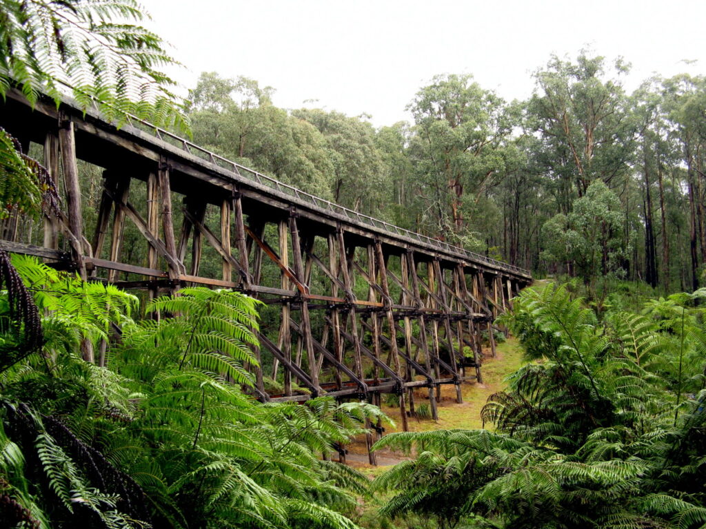
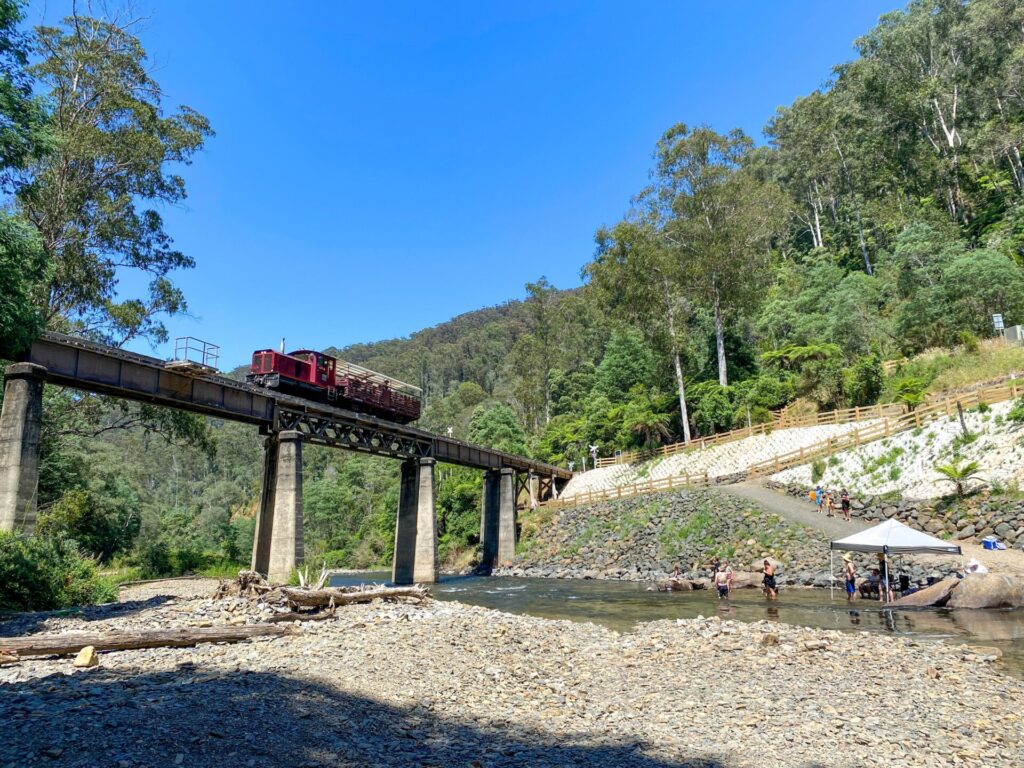
- Heading east from the reserve you will quickly reach the magnificent Bourne Creek Trestle Bridge, which now has a smooth and safe FRP grating deck
- The trail then runs beside the surf beach, so watch for sand drifts
- At Powlett River there is another long trestle bridge, which retains timber decking. A wind farm with six, 2MW turbines is on your right
- A flat coastal farmland section follows and then a wooded area where koalas have been seen. Just before the South Dudley Rd carpark, there’s the State Coal Mine Historic Reserve, which has a walking track.
- From this carpark, the trail is sealed and has solar lighting. Horses are not allowed on the town section
- The trail continues to the railway station precinct and then Bent St and the improved East Area Trail, currently being extended to Inverloch
- Wonthaggi is a large regional centre with all facilities. If starting here, aim for the Wonthaggi Centennial Centre, where there’s car parking, toilets and an information desk
![Leaving the rather underwhelming start of the trail at Woolamai [2025]](jpg/v21-150-leaving-the-current-start-of-the-bcrt-at-woolamai-2025-img_6862-1-300x222.jpg)
Leaving the rather underwhelming start of the trail at Woolamai [2025]
![Coastal vegetation dominates heading west towards Anderson [2022]](jpg/v20-160-coastal-vegetation-dominates-on-the-trail-heading-up-towards-anderson.-wk-2022-img_1047-300x225.jpg)
Coastal vegetation dominates heading west towards Anderson [2022]
The trail hub at Anderson has a horse corral, toilets and bus shelter [2022]
![Horses at Anderson, near turn off to George Bass Coastal Walk [2022]](jpg/v20-212-anderson-horse-2022-12-8935-300x168.jpg)
Horses at Anderson, near turn off to George Bass Coastal Walk [2022]
![Views of Nobbies and lush farms between Anderson and Kilcunda [2008]](jpg/v20-209-anderson-2008-09-5315-family-300x200.jpg)
Views of Nobbies and lush farms between Anderson and Kilcunda [2008]
![Please give way to wildlife! They also use the trail to get around [2022]](jpg/v20-212-anderson-kangaroos-2022-12-03_094434-300x169.jpg)
Please give way to wildlife! They also use the trail to get around [2022]
![Looking towards the coast at Kilcunda with wind turbines in distance [2008]](jpg/v20-259-kilcunda-2008-09-5322-300x200.jpg)
Looking towards the coast at Kilcunda with wind turbines in distance [2008]
![Sun, sand and iconic Bourne Creek Trestle Bridge at Kilcunda [2022]](jpg/v20-265-bourne-creek-bridge-2022-12-8943-300x200.jpg)
Sun, sand and iconic Bourne Creek Trestle Bridge at Kilcunda [2022]
![A view of the intricate timber work under the trestle bridge [2022]](jpg/v20-265-bourne-creek-bridge-2022-12-8963-300x200.jpg)
A view of the intricate timber work under the trestle bridge [2022]
![This really is the trail at Kilcunda where trains used to run along dunes [2025]](jpg/v21-250-only-metres-from-the-beach-at-kilcunda-2025-img_6866-1-300x194.jpg)
This really is the trail at Kilcunda where trains used to run along dunes [2025]
![There's a reason they ask you to walk the Powlett River Bridge [2025]](jpg/v21-300-theres-a-reason-they-ask-you-to-walk-over-the-powlett-river-bridge-2025-img_6867-1-300x200.jpg)
There's a reason they ask you to walk the Powlett River Bridge [2025]
![Spring rains fill wetlands near Bruce Creek. Wind turbines beyond [2022]](jpg/v20-310-spring-rains-fill-the-wetlands-near-bruce-creek.-the-powlett-river-wind-turbines-are-barely-visible-in-the-background.-wk-2022-img_1055-300x225.jpg)
Spring rains fill wetlands near Bruce Creek. Wind turbines beyond [2022]
![Parking area in South Dudley Rd, Wonthaggi, has a bike repair station [2022]](jpg/v20-362-the-parking-area-in-south-dudley-road-wonthaggi-features-a-bike-repair-station.-horses-can-use-the-trail-west-from-here.-wk-2022-img_1076-300x225.jpg)
Parking area in South Dudley Rd, Wonthaggi, has a bike repair station [2022]
![The trail goes further east, to Bent St and Wonthaggi Information Centre [2025]](jpg/v21-350-former-goodshed-and-railway-station-museum-at-wonthaggi-2025-img_6870-1-300x220.jpg)
The trail goes further east, to Bent St and Wonthaggi Information Centre [2025]
![State Coal Mine Museum is a reminder of area's major coal industry [2025]](jpg/v21-350-state-coal-mine-wonthaggi-2025-img_7315-300x169.jpg)
State Coal Mine Museum is a reminder of area's major coal industry [2025]
GIPPS the LAND of paths less cycled
Public Transport
There are PTV buses from Melbourne to Koo Wee Rup and then another PTV regional service onward from Koo Wee Rup to stops from Anderson and Wonthaggi.
There are also local buses (South Coast Bus and Phillip Island Bus, phone 03 5952 2500) servicing towns on the Bass Coast Rail Trail route between Anderson and Wonthaggi. Please note that some of these buses are fitted with bicycle racks, providing an easy option for getting back. Loading instructions are given in the carrying restrictions link here.
Refer to the PTV website for route map and timetables, or your navigation app of choice.
Do you know of a bike hire or transportation service on this rail trail that should appear here? If so, let us know at admin@railtrails.org.au.
Information and Links
![]() This rail trail is managed by Bass Coast Shire, 76 McBride Ave, Wonthaggi, Vic 3995
This rail trail is managed by Bass Coast Shire, 76 McBride Ave, Wonthaggi, Vic 3995
Please report any issues (or compliments) to the rail trail managers:
Phone: 03 5671 2211 or 1300 BCOAST (226 278), email: ba*******@***************ov.au
For further information
- Bass Coast Rail Trail brochure here
- For Wonthaggi State Coal Mine and George Bass Coastal Walk, try Parks Victoria. Ph: 13 1963 or www.parkweb.vic.gov.au
- Visitor information Wonthaggi, Ph: 1300 854 334
- Visitor information Phillip Island, Ph: 1300 366 422
Contact Rail Trails Australia
To contact us about this rail trail, email vic@railtrails.org.au
Background Information
Traditional owners
We acknowledge the people of the Bunurong as the Traditional Owners and Custodians of this land and waters on which the rail trail is constructed.
Development and future of the rail trail
Bass Coast Shire Council are seeking funding to extend the trail 24km north to Nyora, where the Wonthaggi branch line started
Railway history
The Wonthaggi Line opened in 1910 to serve the State Coal Mine, but it was also used by passenger and general goods trains.
The mine’s production rapidly grew and, at its peak, in 1926 it produced 2474 tons per day with the Victorian Railways buying 90% of it. By 1928, 12 passenger services ran on the line per week, with a journey from Flinders St to Wonthaggi taking about four hours.
Victorian Railways gradually changed from steam to diesel-electric locomotives, reducing demand for black coal and, in 1968, the mine closed. Passenger trains from Nyora to Wonthaggi were withdrawn on 4 December 1977 and the line closed on 21 November, 1978 after the last goods train left from Melbourne.
Major Upgrade to Wonthaggi Station Precinct
Posted: 10/08/24
The Wonthaggi Station Museum Precinct has received a major facelift, including transformation of the Bass ...
More...Gippsland Trail Link Progress
Posted: 18/09/23
The plan to link the Great Southern Rail Trail and Bass Coast Rail Trail at ...
More...New rail trail connection in Victoria’s south being pursued
Posted: 04/10/22
Funding for a rail trail extension from Woolamai to Nyora will be sought by the ...
More...Nearby Trails
Red Hill Rail Trail
Mornington Peninsula, 90km south of CBD
6.3 km


Great Southern Rail Trail
South Gippsland, 130km south-east of Melbourne
136 km


Mornington Rail Trail
Mornington Peninsula, 60km south of CBD
4 km

Grand Ridge Rail Trail
Strzelecki Ranges, 160km east of Melbourne
13 km
Eastern Dandenong Ranges Trail
Dandenongs, 50km south-east of CBD
15 km
Rokeby to Neerim Railside Trail
West Gippsland, 100km from Melbourne
17 km
Ringwood to Belgrave Trail
40km east of Melbourne CBD
17 km
Moe – Yallourn Rail Trail
Latrobe Valley, 130km east of Melbourne
7.2 km
Noojee Trestle Bridge Rail Trail
West Gippsland, 100 km east of Melbourne
3 km
Powelltown Tramway Trails
Yarra Ranges, 80km east of Melbourne
39 km
Rosstown Rail Trail
Southern suburbs, 9km from the CBD
9 km
Warburton Rail Trail/Yarra Valley Trail
Yarra Valley, 50km east of Melbourne CBD
48 km
Outer Circle Rail Trail
Eastern suburbs, 6km from Melbourne CBD
17 km
Hawthorn to Kew Rail Trail
Inner suburbs, 9km east of Melbourne CBD
1 km
Tyers Junction Rail Trail
Baw Baw Ranges, 30km north of Moe
7 km
Sandridge Rail Trail
Melbourne city, 1km from GPO
4 km
Webb Dock Bridge
Docklands, 1 km south-west of Melbourne GPO
0.2 km
Bellarine Rail Trail
Bellarine Peninsula, 75km south-west of Melbourne CBD
35 km
Inner Circle Rail Trail
Inner suburbs, 5km from the CBD
5 km
Erica to Thomson Rail Trail
Baw Baw Ranges, 165km east of Melbourne
7.3 km
Meadowlink Linear Park
Broadmeadows, 20km north of CBD
1.2 km
Fyansford Rail Trail
North Geelong, 5km from town centre
4.4 km
Nearby Trails
Red Hill Rail Trail
Mornington Peninsula, 90km south of CBD
6.3 km
Great Southern Rail Trail
South Gippsland, 130km south-east of Melbourne
136 km
Mornington Rail Trail
Mornington Peninsula, 60km south of CBD
4 km
Grand Ridge Rail Trail
Strzelecki Ranges, 160km east of Melbourne
13 km
Eastern Dandenong Ranges Trail
Dandenongs, 50km south-east of CBD
15 km
Rokeby to Neerim Railside Trail
West Gippsland, 100km from Melbourne
17 km
Ringwood to Belgrave Trail
40km east of Melbourne CBD
17 km
Moe – Yallourn Rail Trail
Latrobe Valley, 130km east of Melbourne
7.2 km
Noojee Trestle Bridge Rail Trail
West Gippsland, 100 km east of Melbourne
3 km
Powelltown Tramway Trails
Yarra Ranges, 80km east of Melbourne
39 km
Rosstown Rail Trail
Southern suburbs, 9km from the CBD
9 km
Warburton Rail Trail/Yarra Valley Trail
Yarra Valley, 50km east of Melbourne CBD
48 km
Outer Circle Rail Trail
Eastern suburbs, 6km from Melbourne CBD
17 km
Hawthorn to Kew Rail Trail
Inner suburbs, 9km east of Melbourne CBD
1 km
Tyers Junction Rail Trail
Baw Baw Ranges, 30km north of Moe
7 km
Sandridge Rail Trail
Melbourne city, 1km from GPO
4 km
Webb Dock Bridge
Docklands, 1 km south-west of Melbourne GPO
0.2 km
Bellarine Rail Trail
Bellarine Peninsula, 75km south-west of Melbourne CBD
35 km
Inner Circle Rail Trail
Inner suburbs, 5km from the CBD
5 km
Erica to Thomson Rail Trail
Baw Baw Ranges, 165km east of Melbourne
7.3 km
Meadowlink Linear Park
Broadmeadows, 20km north of CBD
1.2 km
Fyansford Rail Trail
North Geelong, 5km from town centre
4.4 km
30 reviews of “Bass Coast Rail Trail”
Nice trail , with a good surface . Looking forward to the extension to Wonthaggi . The weather was good .
RT61/70 Good to see there’s now traffic lights and a centre refuge to get to the shops at Kilcunda
Rode today. Weather was a bit squally early on; but, cleared to be fine & cool. Trail is in great condition ATM even though it was a little damp in parts. Views, especially around Kilcunda, were spectacular. We started at Wonthaggi & rode to Woolamai Racecourse return. Thanks to everyone involved with trail. I hear there are plans to extend in both directions, which would be awesome. Also, big shout out to the team at Wheel Heat, the bike shop in Wonthaggi. Visited there when we got back to sort out some gear shifting problems. Arrived unannounced & they went out of there way to help. Thank you!
Scenic trail for sure this one & a lovely route n either direction, return cycle if you have the energy even better. I usually start from Woolamai & it is gradual uphill through farmland and nice distant views. Then the main section is a coastal ride with stunning views around Kilcunda of the Bass Coastline. It is pretty a pretty gentle incline at each end then a gentle descent to follow. There’s nothing at the Woolamai end of much interest but Wonthaggi at the other is a bustling coastal town with cafes, shops, some rail history & a good information centre. 23 km each way … one of my favourites !
Sadly, the weather was bad. Still after a nice pub stay at Wonthaggi I started early in very strong winds and rain. Even in these conditions the ride was interesting, and it was a blast to reach Bass strait literally as the rain was horizontal! The surface was a bit sticky. Highly recommended for the scenery and easy distance. While planning to ride to Melbourne I pulled the out due to the weather at the very handy Anderson coach stop folding my Bike Friday 20" tourer and catching bus back to Melbourne and overnight to Sydney towards home.
Rode this trail today from Wonthaggi and return. Wonthaggi is a great little town with good shopping and accommodation options. The trail surface has been greatly improved since I was last here, and it is a real pleasure to ride on. The small township of Kilcunda has grown since I was here before, and it is really buzzing with coffee shops, pub and motel. We were lucky to have wonderful weather. This is one of the best trails in Victoria
Public Transport Access: I caught the Met Train from Sunbury to Frankston then Stony Point with my bike and the ferry to French & Phillip Island with the plan to camp for a week. I was happily surprised to see the local bus service with bike racks on the front and caught the bus to Kilcunda right on this rail trail. It was a hot week so the mix of cycling/surfing/swimming and being lazy with the bus back some days was wonderful. The return public transport trip on Sunday was Seniors free the entire journey to Sunbury.
Did this trail November 14, 2023. My first trail out of Melbourne. Started at Woolamai, to Wonthaggi and returned via Powlett River mouth. An excellent ride through lovely coastal country. Trail was in excellent condition. An easy and relaxing ride, not too far from Melbourne.
Today I parked at Anderson bus interchange and rode my hybrid e-bike on the return trip Anderson-Wonthaggi.
Surface is bitumen within Wonthaggi town boundary and packed fine gravel elsewhere. Surface is good.
The drive from Melbourne Eastern suburbs is about 90mins each way if only VLine coaches would accept bikes
Wonthaggi town isn't especially bike friendly, only a few painted bike lanes and with exception of the Centennial Centre (on trail) I could not find any bike parking hoops near the retail shops and cafes. Not even bike parking at the Wonthaggi bus interchange
Historic information boards re mining and rail history have been vandalised so you have to rely on Google
Great trail. Love this area. does anyone know when the Woolamai to Nyora section wiull be done / completed? It would be fantastic to likn this trail to the Great Souther Trail.
ps.refreshed browser and RTA has updated the closure. Oops should have done that yesterday!
Thanks for letting us know know Kylie.
We will work with council so they let us know about these issues prior to work starting but on the bright side at least Bass Coast Shire Council is doing a great job of maintaining this wonderful rail trail.
Feb 14, 2022
NB – only did 5km out from Wonthaggi.
We set off from Wonthaggi to Kilcunda and 5km in there was a sign advising trail closed to Kilcunda due to bridge works. Would have been great to have this sign at the start!
The track was mainly unsheltered so make sure you wear sunscreen. Pretty cruisy riding – daughter had road bike and it was fine.
Great trail. In good condition. Great coastal views either side of Kilcunda. At the moment some trees over the trail after the storm, but you can get through. Absolutely recommend it to anyone
I couldn’t wait to get out after Covid 19 restrictions so I started this new section at Woolamai Race Track after parking awkwardly on McGrath Rd. (there are no road signs showing where the Bass Trail starts). Its a beautiful wide path up hill to Anderson with excellent views all round. Anderson round about has toilets and its a lovely path onward to Wonthaggi but it was crowded being a long weekend. One concern is a dangerous crossing at the busy Bass Highway above Kilcunda (I hope they put a bridge or tunnel here). On the return trip it became dark but with my good headlight I really enjoyed it. I must mention here I also did the path from Anderson to San Remo, its for mountain goats as there are some ridiculous steep sections however its safe away from the very busy Phillip Island Road.
Our group of 10 cycled from Wonthaggi to Kilcunda on 20 March 2020 on a beautiful sunny day but with a fierce headwind all the way. Had a great time – good dry surface and wonderful views. Our only concern was the suggestion to park at the Railway Museum or shopping centre car park which had a 2 hour limit. We thought that parking at the Visitor Centre and Gallery was a better option as there were some all day parking spaces.
Rode this trail on the 11th of August 2019, riding Wonthaggie to Anderson’s return. In the days leading up to the ride it had been raining heavily, and when we started the trail was covered in a layer of sleet. However, the gravel surface was in great condition and there were people riding it on gravel bikes. There was one section that was under about 20cm of water, and resulted in wet feet which certainly adds to the adventure.
Despite its location the trail is generally well sheltered from the wind, and it has great views of the coast and the countryside. Certainly recommend a coffee at the General Store in Kilcunda, and lunch at the Wonthaggi Hotel was a great way to finish the ride.
It would be great if the trail were a little longer to make more of a day of it.
13/27. We did this rail trail over Easter on a lovely day, but even if it wasn’t sunny, this trail would still be stunning. A nice easy surface along the entire track, much better than the last time i rode it about 10 years ago. We rode the Woolamai to Wonthaggi direction to get the tail wind, and also so we could finish at the Wonthaggi Hotel, which is right at the end of the trail, for lunch. The iconic views at Kilcunda are not to be missed. We had a coffee break at the General Store there to soak it all in.
The only real hill is up to Anderson, but it is not steep in typical railtrail fashion.
I’m riding every ail trial in Victoria this year to promore organ donation. You can follow my other rail trail exploits on FB Warwick Duncan – The 2nd Chance Man or Insta @warwick_rides.
I rode the Anderson to Wonthaggi section and return on the 10/6/17. This was the 1st rail trail I have ridden and I loved it. The track was in great condition and the coast along Kilcunda was a lovely bonus. Plenty of bird life the occasional rabbit or Kangaroo and curious cows. Overall a very enjoyable 34 klm ride and highly recommended. Looking forward to riding more trail trails in the future and definitely be back to ride the Bass Coast trail trail again.
Rode the trail on 28.02.16. Started at McGrath Rd in Woolamai, you can see the start of the trail, but there are no signs anywhere saying this is a rail trail or in fact it is the Bass Rail trail. We just assumed that was it and when we saw the first marker we knew we were at the right place. There is no parking at McGrath Road, you need to find a place on the side of the road in the grass verge. I assume this will be fixed when it is extended to the Rec reserve.
A nice ride through to Wonthaggi and back. pretty long climb (around 5km) at the start, probably why we saw no one else on the first section. Worth doing, we enjoyed the coastline at Kilkunda, great scenery.
Our first ever rail trail and we are now hooked! We rode it with loaded touring bikes no problem. Had to stay on the edges though as horse hooves had cut up the centre quite a bit. Otherwise superb.
I did this trail with my 14-year old son recently (in conjunction with the ‘Grand Ridge Rail’). It is an easy run to Kilcunda from Wonthaggi, nothing spectacular, but lovely as one approaches the coast. One can see broad sweeps of coastline to one side of the trail and the rolling hills of Gippsland on the other. The old Kilcunda Bridge is a thrill with the crashing surf next to you. Wonthaggi has plenty of dining options (Connell’s Bakery near Safeway is one of the best), and Kilcunda has a notable pub with views of the coast. What more could you want? Highly recommended. It’s a pity it does not extend to Inverloch by the coast as well. Inverloch is paradise ever on a bad day.
Rode the trail from Wonthaggi to Anderson with beautiful scenery. Trail surface damaged west of Kilcunda by horses presumably in wet weather.
I rode this trail 10/12/14 , previous time was 3 years ago. Probably because of the recent weather the trail has become quite rough in particular the stretch from Anderson to Woolamai. The main damage has come from horses. The track is also getting dangerous at the road crossing points, the surface falls away quickly and there are deep ruts in the crossing styles. The camber of track is fairly severe in places and could be difficult even for a hybrid with smoother tyres. The names at the roads crossings are not displayed. This ride could be a real attraction for trails riders if it was properly maintained and promoted. The motorbike ruts don’t help either.
I rode this trail on the 19th November 2014. Perfect day for it – sunny without any wind. The ride between Wonthaggi and Kilcunda is the best part – along the coastal dunes – though the views from Anderson are just as good. The trail surface is good – though it’s a shame the trail just ends in the middle of nowhere outside of Woolamai. Beware there was a swooping Grey Butcherbird right near the top of Anderson hill (as you cross the gravel road) which was pretty fearless in attacking me.
Rode this trail early March 2014. Trail surface good all the way. There was some sand on the trail near the Kilcunda trestle bridge, and a few ‘ruts’ in other places, but otherwise my bike (a portable / foldup with MTB rim on the back and standard road / hybrid rim on the front) had no problems travelling it. Well worth effort to ride this trail as it is fairly flat except for the section between Kilcunda and Anderson which has some grades. Watch for crosswinds near Kilcunda, and roos between Kilcunda and Powlett River!
I rode the trail a couple of days ago on a touring bike with a 25mm front tyre and 28 mm on the back. No problems at all so a hybrid should be OK.
Hi Nancy, I haven’t ridden this trail myself but according to the Trail tab of this description page, the blue indicators on the right show that the trail is suitable for touring/hybrid and mountain bikes, among other things. Enjoy! And feel free to comment again with your experience of the ride. Cheers!
Does anybody know if hybrid bikes are suitable for riding on this trail? Much appreciated. Nancy.
I ride this rail trail frequently. It’s a gravel surface, recently upgraded near the Powlett River. Much of the trail is quite sheltered, there are great views from the Powlett River Bridge across farmland to the Desal Plant and then fabulous ocean and beach views as you get close to Kilcunda. It’s a fairly easy ride from Wonthaggi and there’s a lovely cafe at Kilcunda.