 Location:
 Length:
 Surface:
 Start / End:
 Suitable for:
The Murray to Mountains is one of Australia's premier rail trails, with its entire 137km sealed. It connects the great towns of Wangaratta, Myrtleford, Bright, Beechworth and Yackandandah in the mountains and links Rutherglen to Wahgunyah on the Murray River.
- It’s one of Australia’s best known and most popular rail trails
- You can split it up into a variety of rides, or even just do the downhill sections
- This is the perfect introduction to north-east Victoria’s mountains, valleys, history, gourmet produce and wines
- The whole trail is sealed and on gentle grades, apart from the stretch from Everton up to Beechworth and down to Yackandandah.
- New artworks at several locations along the Wangaratta to Bright and Beechworth sections
- There are plenty of other riding and walking opportunities in the area.
Nearby Attractions
- Milawa gourmet region, using shared path from Oxley
- Eldorado, Lake Buffalo, Mt Buffalo, Stanley and Wandiligong
- Renowned Rutherglen wine region
- Bright’s spectacular autumn colours and alpine scenery
- Beechworth’s cooler climate vineyards with spectacular autumn displays
- Yackandandah and Bright have extensive mountain bike parks
Last updated: 19 January 2026
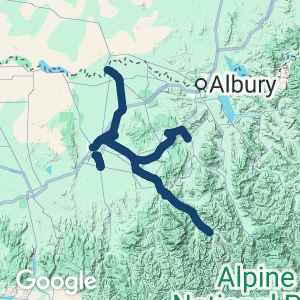
The Murray to Mountains offers a rich variety of experiences, from the Murray River in the north to the foothills of the Australian Alps to the east. The region has a strong focus on visitors, exemplified by its Ride High Country initiative. The rail trail actually encompasses four branch lines. There are gaps in the network, with connecting routes that may involve riding on roads. There are numerous ways to extend your ride or walk, or shorten it.
The four main sections of the M2M, which is all sealed, are:
- Wangaratta to Bright (82km): Follows the picture-perfect Ovens Valley, which produces hops, berries, nuts and grapes, via Everton and Myrtleford to the foothills of the Great Dividing Range and easily split over three days
- Everton to Yackandandah (38km): Climbs quiet steeply to historic Beechworth and then follows an undulating route to Yackandandah with some great views
- Wangaratta to Oxley (9km): Basically flat, this section follows part of the route of a narrow-gauge railway through the King Valley and past the Milawa gourmet area
- Rutherglen to Wahgunyah (8km): Another flat stretch, across the famous Rutherglen wine-growing area with an on-road connection from Bowser.
Wangaratta is a major regional centre with a range of historic buildings, parks, restaurants, accommodation options and a train service. For public transport options, scroll down to GET AROUND and click on SHOW MORE if necessary
There are ESTA marker posts along the trail. In an emergency, call 000 and quote the alpha-numeric code on the post nearest to you, for example MTM111, to get help.
Section Guides
Wangaratta to Everton (26km)
- Access: The Wangaratta trailhead is in Apex Park on Clements Rd, west off Parfitt Rd (C314) and just north of the Ovens River road bridge. It has toilets, a large picnic shelter and parking. There is a poorly marked route to the trailhead from Wangaratta Station (see map)
- The railway to Bright left the main line at Bowser, 8km north of town. As the North East Line is still fully operational, the rail trail uses a network of shared paths, a levee bank and disused roads to get to Bowser
- From Apex Park, a shared path runs under the road bridge and onto the levee bank before paralleling the C314 to Bowser, which has the first of many rest areas with a steam-locomotive theme. Here the road route to Rutherglen heads north on Morrison Rd (see CONNECTING PATHS)
- The trail now heads south-east on the railway alignment across flat farmland, with distant views of the Everton Hills, to the Londrigan Station site, home of the Magpie Family sculpture and start of a side trip Eldorado (see below)
- After 11km the site of Tarrawingee Station is reached before the trail climbs gently to the Everton Station trail hub, formerly the junction for the branch line to Bright
- The trail to Beechworth soon heads to the left; the Bright one to the right
- Slightly further (2km) towards Bright, there’s an arrowed route down quiet Diffey Rd to the Everton village, which has a general store/cafe, hotel and budget holiday park. There’s also another on-road link from there to Milawa (see below)
Everton to Myrtleford (26km)
- Access: The Everton Station trail hub, with the usual facilities, is on White Post Rd off Beechworth-Wangaratta Rd (Search: Everton Railway Station)
- This section undulates through farmland and native bush before climbing to Taylors Gap
- Here the railway cutting has been filled in but the foundations of the steam engine water tank remain, near the one provided for boiling trail users
- Enjoy the descent through Gapsted to Myrtleford
- At Myrtleford much of the railway easement has been sold, so you need to follow the ‘Rail Trail’ signs through town
- Alternatively, you can follow the Ovens River Trail and rejoin the rail trail via Lewis Ave and Albert St
- Myrtleford has plenty of accommodation options and facilities, including a bike shop.
Myrtleford to Bright (30km)
- Access: Myrtleford does not have a trail hub but there is parking near the Albert St/Elgin St intersection where the trail crosses. Toilets are in Jubilee Park on Myrtle St (B500)
- The trail rejoins the original alignment at Jones Park, on Myrtle St, then rises gently as it follows the Ovens Valley to Bright. Mt Buffalo looms on the right and the High Country approaches in front.
- Farms growing berries and grapes may tempt you to make a detour to taste their wares
- At Porepunkah, a popular summer holiday destination, the trail passes beneath the highway bridge
- Take a dip in the nearby Ovens River if the day is warm enough
- The trail follows Back Porepunkah Rd and returns to the railway corridor
- It continues to Bright Railway Station, now a museum, open on Sundays and by arrangement
- If travelling the rail trail west from Bright, there is a trailhead area on Burke St
- Bright is another popular holiday town with its proximity to the alpine area. It is a regional centre with many facilities and more trails (see CONNECTING PATHS).
Everton to Beechworth (16km)
- Access: The Everton Station trail hub on White Post Rd, Everton
- This section is peaceful and attractive, with a mixture of bush and farmland. It has one of the steepest grades that were allowed for a broad-gauge branch line, so some may find it more peaceful travelling in the opposite direction
- The last part is a gentle descent to the restored Beechworth Station. Turn left at Albert Rd and follow that into town or continue on to the Lake Sambell Reserve and Chinese Gardens
- Beechworth has many historic attractions, with festivals and events throughout the year.
Beechworth to Yackandandah (22km)
This section undulates as it descends 240 m to Yackandandah at a gradient similar to the one to Beechworth, with a bonus roller coaster near Yack due to the trail not being in the railway corridor. Unless you are fit or have a freshly charged e-bike, consider staying in Yackandandah overnight before returning
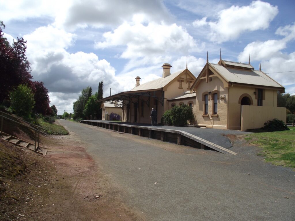
- Access: The trail hub is at the 1876 Beechworth Station near the corner of Albert Rd and Railway Ave (Search: Beechworth Railway Station)
- Heading north, the general route of the railway corridor is followed around Lake Sambell before the trail runs through the residential area
- It then diverges away from the rail easement and becomes a roadside path. At Kibell Lane, it goes back to the railway corridor but it’s shared with resident’s cars for a 3km section that has great views over the valley
- At the end of Kibell Lane, the rail trail proper resumes with some large cuttings and embankments as it continues to descend
- At Star Lane the trail leaves the corridor again as it enters farm land. Turn left onto a roadside path which takes a dogleg down to the main Beechworth-Wodonga Rd (C315) at Wooragee. Some users may prefer to keep going on quiet Star Lane directly to Beechworth Rd as shown on our map
- The off-formation trail along Beechworth-Wodonga Rd is undulating, but with only one short, steep climb
- At Yackandandah Rd there’s a purpose built underpass so trail users can avoid the roundabout
- From there, the rail trail is on the original formation for a scenic kilometre before it runs alongside it. There are great views of the valley and mountains descending to Yackandandah. It is a bit of a roller coaster with the undulations; maybe in the future landowners will allow some of the deeper cuttings on their properties to become part of the trail
- Historic Yackandandah has a lovely main street and all the facilities of a small, popular tourist town
- There is a bit of railway history at the station site, including a well-preserved gantry crane. The nearby brewery has a selection of interesting rolling stock.
Rutherglen to Wahgunyah (8km)
- Access: The Rutherglen trail hub is easy to find next to the information centre at 57 Main St. There’s more parking in Douglas St
- After passing the town’s painted silos and former station, the trail traverses vineyards and farmland to Wahgunyah, where a large Uncle Toby’s production centre signals you’ve arrived
- At Wahgunyah some of the tracks have been left in place for possible use by a rail heritage group. The trail finishes near the Murray River, at another loco-themed shelter, not far from the Culcairn-Corowa Rail Trail in NSW
- Rutherglen and the twin towns of Corowa-Wahgunyah are well set up to cater for visitors.
Wangaratta to Oxley (7km)
- Access: The formal rail trail begins next to Targoora Park at the southern end of town on Wangaratta-Whitfield Rd (Murdoch Rd, C521). It’s possible to get here from town using the service lanes along Murdoch Rd but that’s not ideal. The pleasant One Mile Creek Path will get you from Cusack St to Wenhams Lane and a shared path through Targoora Park to the start
- The trail now travels along the railway corridor, which just happens to have been built in the Wangaratta-Whitfield Rd reserve
- Before reaching the Hume Fwy, the path crosses to the eastern side of the road to get under a freeway bridge at King River
- After rejoining the railway reserve, the trail returns to the western side and continues to Glenrowan-Myrtleford Rd (Snow Rd, C512), site of Oxley Station and current end of the rail trail
- An 8km shared path from here crosses Wangaratta-Whitfield Rd and proceeds adjacent to Snow Rd to the Oxley and Milawa townships.
CONNECTING PATHS
Rutherglen Link (42km): For those keen to ride from the main rail trail to Rutherglen, a 42km on-road option from Morrison Rd, Bowser, is shown on our map. All roads are 100 km/h and have no shoulders. The first section to Springhurst uses lightly trafficked roads, while Springhurst-Rutherglen Rd (C376) has regular traffic. Note when turning off the rail trail at Bowser that Morrison Rd is unsealed while Byawatha Rd, 1.5km further on, is sealed. To go via Chiltern and its famous bakery is an extra 20km. If you must, at the Springhurst overpass continue straight on Gayfer Rd, turn right at the T-intersection onto a bitumen road then left on to a gravel one past a few farms to Horns Access Rd. Turn left into a tunnel beneath the highway, then over the railway and on to Racecourse Rd and follow the signs to Chiltern. After your pastry fix, follow the blue signs featuring R for Rutherglen along Old Howlong Rd and Cornishtown Rd into Rutherglen, a total distance of close to 70 km
Eldorado Loop (18km): Heading east from Bowser, at the Londrigan Station site near Wangaratta-Eldorado Rd, cyclists can make an on-road diversion east to the massive Cock’s dredge at Eldorado, before returning to the rail trail southwards via Eldorado-Tarrawingee Rd. Eldorado has public toilets and a general store.
Milawa Link (16km): Take the marked exit from the trail to Bright, 2 km east of the Everton Station trail hub, down Diffey Rd to the Everton village and follow the arrows. After nearly 1 km on the busy Great Alpine Rd it’s on quiet back roads, with some gravel short cuts available (see map) to Milawa. The Milawa and Whitfield trails will get you back to town.
Great Valley Trail (27km): A pleasant shared path between Bright and Harrietville. The trail follows the Ovens River and explores the beautiful valley between Bright and Harrietville. The trail is flat and fully sealed, suitable for both road bikes and mountain bikes. Follow the rail trail from the centre of Bright towards the Tawonga Gap turnoff and then wind your way through eucalypts and a spectacular valley to arrive in Harrietville where you can find refreshments (here)
Bennetts Trail (5.5km): Another pleasant trail extending from Bright, past the Mystic MTB Park, to the old mining town of Wandiligong. This easy 11 km-return ride follows Morses Creek alongside farmland and over bridges. Watch paragliders float to the ground as you pass the landing paddock (here)
Yackandandah to Osbornes Flat (6.5km): This 13 km-return trip follows picturesque Yackandandah Creek down to the Osbornes Flat area. For the keen rider wanting to connect with other rail trails this shared path brings you closer to the High Country Rail Trail (here)
Rutherglen Loops (various distances): Explore this famous wine region on 48 km of trails linking cellar doors, the Murray River and Lake Moodemere using the rail trail here
![The trailhead in Apex Park, Wangaratta, is next to the Ovens River [2009]](jpg/v41-057-2009-01-wangaratta-6206-300x200.jpg)
The trailhead in Apex Park, Wangaratta, is next to the Ovens River [2009]
![Locomotive-themed shelter at Bowser is first of many along the way [2009]](jpg/v41-106-bowser-shelter-2009-10-5443-300x225.jpg)
Locomotive-themed shelter at Bowser is first of many along the way [2009]
![Massive magpies at Londrigan Stn site, south-east of Bowser [2025]](jpg/v41-105-longridan-2025-05-art-sculpture-img_6101-300x169.jpg)
Massive magpies at Londrigan Stn site, south-east of Bowser [2025]
![Everton Station site is where the trail splits up; either up to Beechworth or on to Bright [2025]](jpg/v41-150-everton-station-2025-12-22_144644-300x169.jpg)
Everton Station site is where the trail splits up; either up to Beechworth or on to Bright [2025]
![Walkers stride between Everton and Myrtleford [Helen Newman, 2021]](jpg/v41-213-everton-to-myrtleford-b2b-walk-2021-03-dsc00052-300x200.jpg)
Walkers stride between Everton and Myrtleford [Helen Newman, 2021]
![Waking the kids near Gapsted for a view of Mount Buffalo [2008]](jpg/v41-212-2008-10-everton-0977-300x225.jpg)
Waking the kids near Gapsted for a view of Mount Buffalo [2008]
![Approaching Myrtleford using a particularly solid railway bridge [2006]](jpg/v41-256-everton-to-myrtleford-2006-04-084-300x225.jpg)
Approaching Myrtleford using a particularly solid railway bridge [2006]
![Arriving at Myrtleford from Bright with Mt Buffalo in the background [2021]](jpg/v41-257-myrtelford-looking-east-2008-09-5369-enhance-300x200.jpg)
Arriving at Myrtleford from Bright with Mt Buffalo in the background [2021]
![Typical scenery in Ovens River Valley of hop and tobacco drying kilns [2006]](jpg/v41-256-everton-to-myrtleford-2006-04-085-300x225.jpg)
Typical scenery in Ovens River Valley of hop and tobacco drying kilns [2006]
![Walking under the clouds between Myrtleford and Eurobin [2021]](jpg/v41-307-ovens-to-eurobin-b2b-walk-2021-03-mtom-2-300x225.jpg)
Walking under the clouds between Myrtleford and Eurobin [2021]
![Beautiful scenery as spring welcomes visitors near Eurobin [2008]](jpg/v41-357-eurobin-2008-09-5371-enhance-300x200.jpg)
Beautiful scenery as spring welcomes visitors near Eurobin [2008]
![Eurobin Station site is a popular stop with shelter and toilets, and new artwork celebrating indigenous history and the critical bogong moth. [2025]](jpg/v41-350-eurobin-station-2025-12-22_164215-300x169.jpg)
Eurobin Station site is a popular stop with shelter and toilets, and new artwork celebrating indigenous history and the critical bogong moth. [2025]
![Eurobin, overshadowed by snow-covered Mt Feathertop [2012]](jpg/v41-358-eurobin-to-porepunkah-2012-07-4128-walk-300x200.jpg)
Eurobin, overshadowed by snow-covered Mt Feathertop [2012]
![Another popular business for riders and walkers in Porepunkah [2021]](jpg/v41-410-2021-04-14_crowded-rail-trail-cafe-at-porepunkah-300x225.jpg)
Another popular business for riders and walkers in Porepunkah [2021]
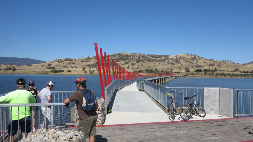
![Leaving Porepunkah for Bright there is a new bridge and colourful artwork along the way [2025]](jpg/v41-400-porepunkah-art-work-2025-12-22_173007-300x169.jpg)
Leaving Porepunkah for Bright there is a new bridge and colourful artwork along the way [2025]
![Autumn's rich colours approaching Bright [Greg Hutchison, 2013]](jpg/v41-408-porepunkah-autumn-2013-05-p1610087-300x169.jpg)
Autumn's rich colours approaching Bright [Greg Hutchison, 2013]
![The viewing platform on the Ovens River just before Bright is a great place to take in nature [2025]](jpg/v41-450-bright-ovens-river-bridge-2025-12-22_174848-300x169.jpg)
The viewing platform on the Ovens River just before Bright is a great place to take in nature [2025]
![The leafy approach to Bright is pleasant in summer and colourful in autumn and spring [2025]](jpg/v41-450-bright-2025-12-22_180203-300x169.jpg)
The leafy approach to Bright is pleasant in summer and colourful in autumn and spring [2025]
![Picture-perfect goods shed, like an autumn scene from Oregon [2013]](jpg/v41-459-bright-2013-05-p1610109-300x169.jpg)
Picture-perfect goods shed, like an autumn scene from Oregon [2013]
![Bright Station is now a museum with preserved rolling stock [2021]](jpg/v41-460-2021-04-14_bright-railway-station-300x225.jpg)
Bright Station is now a museum with preserved rolling stock [2021]
![Hitting the long climb from Everton to Beechworth and down to Yack [2025]](jpg/v41-160-hitting-the-long-climb-from-everton-to-beechworth-2025-img_6132-300x225.jpg)
Hitting the long climb from Everton to Beechworth and down to Yack [2025]
![Coffee done, heading home past the Baarmutha Station site [2025]](jpg/v41-510-passing-baarmuta-station-site-at-speed-2025-img_6136-300x225.jpg)
Coffee done, heading home past the Baarmutha Station site [2025]
![Beechworth Railway Station gets a lot of foot traffic from visitors [2021]](jpg/v41-565-2021-04-13_beechworth-railway-station-300x225.jpg)
Beechworth Railway Station gets a lot of foot traffic from visitors [2021]
![Plenty of things to read at Beechworth Station if you have time [2021]](jpg/v41-565-2021-04-13_beechworth-300x225.jpg)
Plenty of things to read at Beechworth Station if you have time [2021]
![Capturing a colourful departure from Beechworth's gardens [TNE 2024]](jpg/v41-550-beechworth-2024-05-autumn-colours-tne-67-of-312-300x200.jpg)
Capturing a colourful departure from Beechworth's gardens [TNE 2024]
![Indigo Shire Council has marked a shared section on quiet Kibell Lane [2024]](jpg/v41-555-beechworth-to-wooragee-kibell-lane-2024-08-07_135914-1-300x169.jpg)
Indigo Shire Council has marked a shared section on quiet Kibell Lane [2024]
![Gerry's Seat on the lane is a place to have a breather and take in the view [2021]](jpg/v41-555-beechworth-to-wooragee-kibell-lane-2024-08-07_140136-300x169.jpg)
Gerry's Seat on the lane is a place to have a breather and take in the view [2021]
![Start of the 'rail trail proper' section at end of Kibell Lane roadway [2021]](jpg/v41-565-beechworth-to-wooragee-kibell-lane-2021-07-07_114348-300x169.jpg)
Start of the 'rail trail proper' section at end of Kibell Lane roadway [2021]
![Cruising down to Wooragee on the way to Yackandandah [TNE, 2024]](jpg/v41-555-beechworth-to-wooragee-kibell-lane-to-star-lane-2024-05-6_crop-300x169.jpg)
Cruising down to Wooragee on the way to Yackandandah [TNE, 2024]
![The shared path beside Star Lane on the way to Yackandandah [2021]](jpg/v41-565-wooragee-factory-lane-2021-07-07_110451-300x169.jpg)
The shared path beside Star Lane on the way to Yackandandah [2021]
![The Yackandandah Rd roundabout underpass has gentle grades [2025]](jpg/v41-610-yackandandah-rd-underpass-2025-img_6158-225x300.jpg)
The Yackandandah Rd roundabout underpass has gentle grades [2025]
![A section of the trail from that roundabout is on the formation [2022]](jpg/v41-600-2022-02-19_151951-yackandandah-rd-to-wooragee-300x169.jpg)
A section of the trail from that roundabout is on the formation [2022]
![Road took rail alignment for a short distance [Chris Kinniard, 2021]](jpg/v41-606-yackandandah-rd-2021-11-08_152926-01-300x200.jpg)
Road took rail alignment for a short distance [Chris Kinniard, 2021]
![Arriving in colourful Yackandandah for a well-deserved break [TNE 2024]](jpg/v41-650-yackandandah-2024-05-9-300x169.jpg)
Arriving in colourful Yackandandah for a well-deserved break [TNE 2024]
![Hand-operated crane at Yackandandah has been well preserved [2022]](jpg/v41-657-yackandandah-station-area-2022-04-16_173545-300x169.jpg)
Hand-operated crane at Yackandandah has been well preserved [2022]
![A brewery and cafe at the Yack Station site in Turntable Lane [2022]](jpg/v41-657-yackandandah-station-area-2022-04-16_173448-300x169.jpg)
A brewery and cafe at the Yack Station site in Turntable Lane [2022]
![There are numerous other attractions in Yack for visitors [TNE 2024]](jpg/v41-650-yackandandah-town-2024-05-11-300x200.jpg)
There are numerous other attractions in Yack for visitors [TNE 2024]
![Leaving Yackandandah at dusk with the railway corridor on the left [2022]](jpg/v41-607-yackandandah-rd-2022-04-16_171405_crop-300x168.jpg)
Leaving Yackandandah at dusk with the railway corridor on the left [2022]
![Even the information centre is steeped in history at Rutherglen [2013]](jpg/v41-708-rutherglen-2013-06-0677-economy-300x169.jpg)
Even the information centre is steeped in history at Rutherglen [2013]
![Start of the short section of trail from Rutherglen to Wahgunyah [2010]](jpg/v41-707-rutherglen-2010-01-p1173438-300x225.jpg)
Start of the short section of trail from Rutherglen to Wahgunyah [2010]
![Rutherglen Railway Station served local wheat growers [2013]](jpg/v41-708-rutherglen-2013-06-0675-300x169.jpg)
Rutherglen Railway Station served local wheat growers [2013]
![Let's go for a walk through Rutherglen on a beautiful winter's day [2022]](jpg/v41-709-rutherglen-2022-06-8401-225x300.jpg)
Let's go for a walk through Rutherglen on a beautiful winter's day [2022]
![Heading from Rutherglen to Wahgunyah for a quick bite to eat [2010]](jpg/v41-707-rutherglen-2010-01-p1173447-300x172.jpg)
Heading from Rutherglen to Wahgunyah for a quick bite to eat [2010]
![Cofield Wines in Wahgunyah is a stop for responsible drinkers [2018]](jpg/7661605529805-300x169.jpg)
Cofield Wines in Wahgunyah is a stop for responsible drinkers [2018]
![Riding between Wang and Oxley, where the trail diverts to Milawa [2011]](jpg/v41-060-oxley-opening-2011-05-0552-300x168.jpg)
Riding between Wang and Oxley, where the trail diverts to Milawa [2011]
![The narrow-gauge line never made it into the hills from Whitfield [2004]](jpg/v41-905-whitfield-6536-300x225.jpg)
The narrow-gauge line never made it into the hills from Whitfield [2004]
![The Great Valley Trail runs from Bright to Harrietville [Alpine Shire Council 2014]](jpg/v41-490-great-valley-trail-between-bright-and-germantown-2014-300x200.jpg)
The Great Valley Trail runs from Bright to Harrietville [Alpine Shire Council 2014]
Attractions along the Oxley/Milawa heritage section
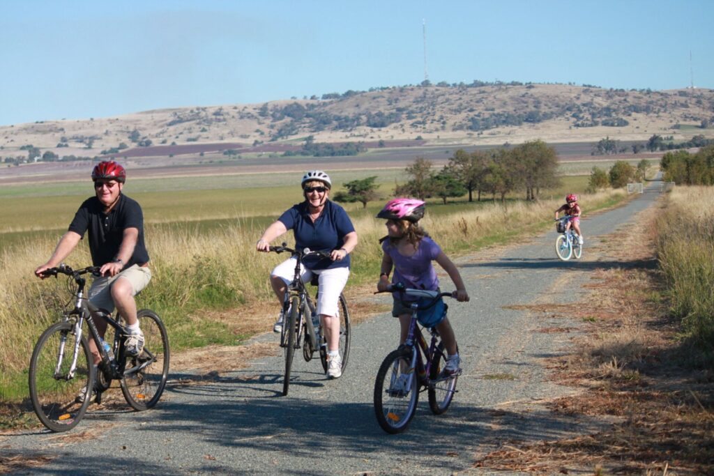
Riding from Bright to Everton

 Self guided & small group guided tours from 1 to 5 days with the Murray to Mountains Rail Trail specialists.
Public transport options on the rail trail are:

The V/Line train Melbourne <> Albury service uses VLocity trains that stop at Wangaratta Station.
The V/Line bus services the Wangaratta to Bright and Wang to Beechworth sections of the rail trail. The Albury <> Bendigo service travels via Rutherglen.
Refer to the PTV web page for map and timetables, or your navigation program of choice.
Refer to VLine’s policy on carrying bikes on trains and coaches.
The Bike Hire Company (Beechworth) – Offers bike hire and transfers but closes for winter. Tel: 0400 345 648 Website: www.thebikehirecompany.com.au
Do you know of a bike hire or transportation service on this rail trail that should appear here? If so, let us know at admin@railtrails.org.au.
Information and Links
The rail trail is managed by Indigo, Wangaratta and Alpine Shire Councils, which are responsible for maintaining their sections.
Contact numbers for their Visitor Information Centres are: ![]()
Wangaratta 1800 801 065
Beechworth 1300 366 321
Bright 1800 111 885
Please report issues with the trail to Tourism North East in**@******************om.au or (03) 5728 2773
The official website is here
Download a rail trail map here
Contact Rail Trails Australia
To contact us about this rail trail, email vic@railtrails.org.au
Background Information
Traditional Owners
We acknowledge the Waveroo people, the traditional custodians of the land and waterways on which the rail trail is built.
Development and future of the rail trail
Construction of the rail trail began at Bright in 1993, and finished in 2002 with the opening of the sections to Wangaratta and Beechworth.
The trail between Rutherglen and Wahgunyah, on the Murray River, was completed in 2009.
The Wangaratta to Oxley section opened in 2011, providing tourism links to the Oxley and Milawa regions. Extension of that trail towards Whitfield is planned.
The extension from Beechworth to Yackandandah opened in 2022.
Rail Line History
The branch line from Bowser (north of Wangaratta) to Everton and Beechworth opened in 1875 and was extended to Yackandandah in 1891. A second branch was built from Everton to Myrtleford in 1883 and extended to Bright in 1890. That made Everton an important railway junction, but little evidence of that remains today. The line from Beechworth to Yackandandah closed in 1956 and from Everton to Beechworth in 1977.
Beechworth, originally known as Mayday Hills, had been a major gold mining centre in the 1850s. You can explore traces of this activity at Woolshed Falls, the Gorge Scenic Drive and the Old Powder Magazine. Beechworth Historic Park surrounding the town has unusual cypress-pine/box woodland and box-leaf wattle.
The line to Bright was popular in the early 20th century with tourists visiting the picturesque town of Bright and Mt Buffalo Chalet, built and operated by Victorian Railways to boost patronage. It outlasted the Beechworth line but closed completely back to Bowser in 1987.
The branch line from Springhurst to Rutherglen and Wahgunyah opened in 1879. Passenger services ended in 1962 and goods services in 1995.
The King Valley route, 49 km from Wangaratta Station to Whitfield, was Victoria’s first narrow-gauge line, with the pretext of reducing the cost of building a line to reach the High Country. It opened in 1899, never went beyond Whitfield and closed in 1953.
Rail trails help bushfire affected communities
Posted: 04/02/20
It may be a little difficult carrying an #EmptyEsky on your bike, but you can ...
More...Beechworth to Yackandandah rail trail update
Posted: 10/07/19
The Indigo Shire Council reported in their "Indigo Weekly Update" (28 June 2019) that the Beechworth to ...
More...Murray to Mountains Rail Trail to extend to Yackandandah
Posted: 25/06/17
In May the Victorian state government has announced that the popular Murray to Mountains Rail ...
More...Funding for High Country and Murray to Mountains Rail Trail links
Posted: 26/02/16
Victorian Minister for Regional Development Jaala Pulford has announced funding of $205,000 to support projects to ...
More...Wahgunyah to Rutherglen Rail Trail (VIC) – Community Event
Posted: 18/11/09
Bring your family with the bikes down to the Rutherglen Wine Experience in Rutherglen to ...
More...Murray to Mountains Rail Trail (North East Victoria) to be Extended
Posted: 11/11/06
The Indigo Shire council has been successful in obtaining funding to construct a further 9km ...
More...Murray to the Mountains Bushfire Update (Vic)
Posted: 19/02/03
The recent fires in North East Victoria have not affected the rail trail, the facilities ...
More...Opening of the Murray to the Mountains Rail Trail (Vic)
Posted: 29/08/02
The offical opening of the Murray to the Mountains Rail Trail has been set for ...
More...Opening of the Murray to the Mountains Trail: Beechworth to Everton (Vic)
Posted: 09/04/01
On Easter Monday the trail from Beechworth to Everton will be officially opened. It takes ...
More...Murray to the Mountains Rail Trail (Vic)
Posted: 14/02/01
Beechworth to Everton A new section of the railtrail from Beechworth to Everton is now ...
More...Murray to Mountains Opening
Posted: 18/02/00
The Bright to Myrtleford section of the Murray to Mountains Railtrail was opened on Thursday 10 ...
More...Nearby Trails
Culcairn – Corowa Rail Trail
Murray region, 520km south-west of Sydney
2 km


High Country Rail Trail
300km north-east of Melbourne
81 km


Dookie Rail Trail
Greater Shepparton, 220km north-east of Melbourne
8 km
Nearby Trails
Culcairn – Corowa Rail Trail
Murray region, 520km south-west of Sydney
2 km
High Country Rail Trail
300km north-east of Melbourne
81 km
Dookie Rail Trail
Greater Shepparton, 220km north-east of Melbourne
8 km
55 reviews of “Murray to Mountains Rail Trail”
Cycled from Bright to Myrtleford and back on 13 January 2026, in very warm weather but no major winds. The trail is in good condition on this section and I appreciated the Eurobin rest area which is well maintained with a large water tank. Distance markers every 1km are new since I was last on the trail (a while ago!). Didn't see many others on the trail, probably too warm for most.
We decided to take this on as a tour ,so the first day we left our car in Harrietville and rode to Myrtleford and camped in the camp ground ,56 km ,nice bakery and Asian restaurant,we then continued on to Wangaratta where we found the signage to be poor and confusing ,eventually finding our way out to Milawa to the camp ground and a nice pub meal 79 km, from milawa we took some well signposted quite roads to Everton then back on the Railtrail to Beechworth for lunch then onto Yackandandah which was mostly downhill to the campground and another pub meal ,64 km .Got an early start and headed along back creek road ,then onto the Yackandandah Myrtleford road to Myrtleford ,then retraced our way back to Harretville 93km. It’s aways a bit hard to cover a Railtrail when you only have one car ,so this makes a good circuit out of it ,and your never to far from a bakery!!
Enjoyed riding from Myrtleford to Bright and back today – so picturesque – apart from last section (about 2km) which we had to ride on the (narrow, winding) road as the rail trail was closed – ? due to maintenance? Would have been good to know this before we left and would have changed our plans. Didn't want to turn back only 2km from Bright as we wanted to see the town! Tourist info didn't seem to know about the closure.
Rutherglen Loops!
Great rail trail and earlier this year I stayed in Rutherglen and discovered the Rutherglen loop trails. The shire has done a fantastic job creating these trails not just linking wineries but tracks along beautiful bushland and a wonderful part sealed section along the Murray River, through scenic Woodlands and waterways. Rutherglen is a lovely town with all the facilities for a few days to a week. Don't miss it.
Hello,
I rode the Rutherglen to Wahgunyah Rail Trail Section yesterday (18/07/25).
I followed the advice of “Ewen H” post’s on the 23/12/23 (on the Corowa – Culcairn Rail Trail Page), and combined it with the Corowa 2km Rail Trail section and Murry River Loop. Thank you very much for your post and advice.
I started/finished at the Heritage Motor Inn – Corowa (thanks Geoff for accommodating me), rode to Rutherglen with a town loop and then back to Wahgunyah and onto the Murray River Section and then anti clockwise back to Corowa Station for a total of 29.7km ride.
Great Trails and the surfaces were all pretty good.
Cheers,
Marty
RT34 Completed the Murray to Mountains groupset yesterday with the ride from Everton to Yackandandah and back. There are new, orange distance posts with Emergency Marker System numbers on them. The new surface on Kibell Lane and concrete spoon drains through the cuttings is a big improvement but the line marking for the on-road bike/walker lane is yet to be done.
The short and pleasant (sealed surface) rail trail from Rutherglen is part of a new network of bike trails linking wineries, Lake Moodemere and Murray River (https://www.explorerutherglen.com.au/ride/rutherglen-loops/). Well worth staying a day or two in Rutherglen to explore, particularly if you are a wine lover. Cofield winery on the bike trail has a decent cafe, and Rutherglen is an attractive town with lots of eating and accommodation options (plus Convent Brewery). Getting there from train stations requires using low-volume but high-speed roads without sealed shoulder: from Springhurst is shorter and we encountered barely 10 vehicles in 16 km (mid-afternoon weekday), from Chiltern you can take the lovely and very low-traffic Chiltern Valley road leaving only 3.5 km on the busier C377 until you join the town bike path near Anderson Winery. Completing the rail trail from Rutherglen to Springhurst would solve this access problem.
RT34 Based myself in the budget caravan park in Everton, as it's fairly central. Rode Everton to Bright return (114 km) on 19/5, then the Everton-Milawa-Wang-Everton loop (72 km) the next day, enjoying the autumn leaves. There's a well-marked route from east of the Everton Station site down Gibbes St to Everton, which was a relief on the way back. Third day I chickened out and drove to Rutherglen rather than take the on-road cycle route to the rail trail there. So only 16 km return, but I did drive across the border to do the Corowa one. This could have been a 127 km day so I feel like I cheated. I have to go back to do Everton-Yack anyway and will enjoy riding the first section of the MTM from Apex Park again along the levee bank towards Bowser, which is now hot-mix asphalt and has a better view, as they have raised it for the benefit of local residents.
What an absolutely wonderful series of trails – with great scenery, cafes, bakeries and wineries.
We rode the following in April 2025:
* the Everton, Wangaratta, Oxley, Milawa, Everton circuit – the on-road section was on flat, sealed, quiet country roads (we were passed by 3 cars and a bus around 4pm on a weekday)
* the Osborne Flats, Yackandandah, Beechworth section is through bushland and it is the most undulating section
* the Beechworth, Everton section is a very relaxing down hill section (heading to Everton!) set in the bush and the Everton to Bright section is relatively flat with views of the valley and mountains.
Although all of the above trails are on sealed paths, the riding would be more comfortable if your tyres are at least 35mm. The Osborne Flats to Yackandandah trail commences at the Osbornes Flat Hall – see www.victoriashighcountry.com.au/listing/m2m-yackandandah-to-osbornes-flat/
Mytleford to Bright, easy cruise and good to see more people on the trails, good flat stretch for a family event with stop offs on the way, cycle surface was pretty good.
Ride the Everton to Beechworth section today, my lord that climb just keeps going! Well worth it though nice cycling through the forest/bush land, a solid workout and Beechworth is a very nice old town to grab a drink and bite to eat.
It’s a clear indigo blue Wednesday morning as I cycle out of Footscray for Southern Cross Station in Melbourne. I board the 7.07am limited express train to Wangaratta, my starting point for a few days cycle touring the rail trails and country towns of North East Victoria .
Exiting Wangaratta Station there’s well signposted directions for the Murray to Mountains Rail Trail (M2M) with a variety of cycling options available.
A hot blustery north wind, made for a testing climb up over Taylor’s Gap, before the moderate downhill run through a mix of bush vineyards and farmland to the valley town of Myrtleford. The trail surface is excellent while the bucolic country views are breathtaking. I shared the ride with native wildlife; An Echidna, Koalas, beautiful Yellow Tailed Black Cockatoos and Kangaroos.
In the evening I set up my small tent on a shady grassy pitch in the Myrtleford Caravan Park. I was woken at 3am by a Boobook Owl calling into the night and I took the opportunity to enjoy a stellar view of a brilliant southern night sky counting constellations and marvelling at the Milky Way.
The next morning, I decided to double back and take the trail to the beautiful historic goldfields town of Beechworth. King Parrots, Gang Gang Cockatoos and Backfaced Cuckoo Shrikes accompanied me on the steady climb to Beechworth where I headed to the Bakery for a tasty bee sting, a sweet honey bun, and good coffee.
On a near perfect cycling day, I decided to push on to Yackandanda (Yack). On the way I took the trail extension downhill to Woogeere, which proved to be an exhilarating, heart pumping mix of loose gravel, paved road and hard compacted rail trail surface that was strewn with fallen tree branches. It was both exciting and slightly dangerous. From Woogeere it was a ‘lumpy‘ roller coaster ride to the Yack Caravan Park and a fresh patch of grass for the evening. Yack is a hip, progressive little town with a friendly vibe and is full of its fair share of eccentrics too.
Waking up refreshed in Yack, I opted to leave the trail for a while to take a backroads tour of Chilton via the Beechworth/Chilton Road which runs beside Mount Pilot National Park. I rode in search of Victoria’s Avian emblem, the critically endangered Regent Honeyeater. A simply stunning ride with a multitude of birds, but not the elusive Regent Honeyeater. I liked Chilton it’s both “Bike and Bird” friendly, with a funky 1950’s rock and roll cafe, my kind of people.
I enjoy cycling quiet country backroads, so took the Chilton/Rutherglen Road to the outskirts of Rutherglen, before rejoining the M2M trail through the prosperous town of Rutherglen where I pushed on to Wahgunyah. I then crossed the mighty Murray River into Corowa NSW. I considered taking the Corowa to Mulwala Cycle Trail (45 kms) and crossing into Victoria again at Yarrawonga, but it was late in the afternoon with rain settling in. I cycled back to Rutherglen, setting up camp in the Rutherglen Caravan Park by Lake King, which is ringed with ancient river red gums.
The rains brought out the large Red Gum Ghost Moths (aka Bardi Grub) in great numbers. I saw them swarming around the walls of the amenities block where they were easily picked off by Magpies and Brush-tailed Possums. In Rutherglen I shared morning coffee at ‘Caffeine n Machine’ with a few members of the outlaw styled ‘God Squad’ motorcycle gang. In pouring rain I took the Rutherglen to Springhurst Road that runs alongside a disused train line. On the outskirts of Springhurst I found Railway Road, a 20km gravel road that runs parallel to the Hume Highway and took me back to Bowser in North Wangaratta, where I rejoined the M2M once more for the cycle back into Wangaratta.
My mini tour was an absolute blast. Go out and get yourself some of that country air, it’s a cracker!
One important section missing from the description of this trail is the 7kms from Yackandandah to Osbornes Flat. It was opened a few years ago. The weekly Saturday morning Yackandandah Rail Trail Parkrun uses this section which runs through bushland along the Yackandandah Creek. There are no road crossings on this stretch of the trail. There is plenty of birdlife including Gang Gang Cockatoos feeding in old Hawthorn Trees together with yellow robins, fairywrens, babblers, kingfishers and several species of honeyeaters. It is a well maintained section with a mixture of concrete and compacted gravel. There are new concrete and steel bridges over the Yackandandah Creek. At Osbornes Flat there are no shops but there is a toilet and water at the Community Hall, which is the turnaround point. There is a lovely picnic spot with a shelter and table at "Ridgway Reserve" which is on Google Maps 600m before the Osbornes Flat Hall. This 7kms section has road access at Yack, then at Mongan Lane (off Racecourse Rd only) and at Osbornes Flat Rd. Most maps show Mongan Lane as a through road, but don't be tempted unless you have a 4wd with snorkel.
Great update, Thanks Im planning a ride up that way in the next few weeks and will be sure to check out Osbornes Flat
Just back this afternoon from another visit to the M2M, and it was fantastic. We did the Beechworth-Yack-Beechworth trip the first afternoon and were thrilled to find the previously perilous middle section finally paved. Hilly and a bit onerous in parts but were lucky to be joined by a koala ambling along the path.
Next day was the easy downhill run from Beechworth through Everton to Myrtleford. Then out to Bright and back. And finally the Bright to Harrietville and back following the Ovens, an absolutely beautiful ride of about 55km. The destinations are as good as the riding, with good accommodation, particularly in Myrtleford, some nice restaurants, and terrific produce to sample, both liquid and solid. We've done most rail trails in Vic, a few in SA and one on NSW, but I think this is my favourite.
Such a good trail. We have done from Wangaratta to Bright and today we did the Everton to Beechworth section again
Such a good trail
Rode three of the four sections last week (Wangaratta to Oxley-Milawa; Rutherglen to Wahgunyah; Wang to Yackandandah). Had ridden the Wang-Bright trail a few years back. All three trails are excellent paved paths. The first two very easy as dead flat and short (each being 18 kms return). The third, Wang to Yack, is a totally different trail. Although paved almost the entire way, there is a lot of uphill. Returning from Yack to Wang, getting out of Yack is quite tough with a few short, but very steep, climbs. I had to get off my bike and walk up three of these. But the rest of the way is a fairly steady and not too tough a climb (Wooragee-Beechworth and Everton-Beechworth) or flat (Everton-Wang). All three trails are quite enjoyable rides.
Almost entirely paved between Bright and Wangaratta so this can be done on a road bike but a gravel bike is more comfortable. Very beautiful ride. I parked in Myrtleford and rode to Wangaratta and back on day 1 and then to Bright and back on day 2. Very small amount of elevation gain so the days are fairly easy riding. Very exposed trail at times so hydration is a must.
Just a quick review of the Yackandandah to Beechworth section of the trail. We did this last year, and there has been a lot of work done at the Beechworth end since then.
This trail is sealed all the way from Yackandandah, even though a lot of the trail is not in the old railway corridor. However it runs through a forest on the old corridor near Beechworth, and this section is now fully sealed. It is actually used as a road for access of nearby residents. The Beechworth end still needs some improvements where it bypasses a nice cutting and users are required to ride on a rutted and loose gravelled road for a couple of kms. Quite a hilly ride for a rail trail, but very enjoyable on my ebike. 🚴♂️🙂
We were in Bright after riding the rail trail, when someone told us about the 27km Cycleway to Harrietville.
While this isnt a rail trail as such, it could very well be. We decided to ride it the next day, and found it to be an excellent trail. It is a very gradual climb all the way to Harrietville, but you don’t really realise until you do the return trip back to Bright.
Great little coffee shop st Harrietville, but not much else.
The track is a wide smooth sealed surface all the way, with bridges, forests, farmlands, and scenery at every turn.
Highly recommended to any bike riding visitor to the area. We loved it.
Springhurst to Wahgunyah via Rushworth review – Dec 2023
The train from Melbourne town arrives at 10am and the one back departs at 6pm so eight hours of exploring and refuelling was to be done. At Springhurst, there is a very small Post Office/shop that was not open on this particular Saturday. I topped up the bidon at the school and rode through the thick grass on the former Wahgunyah line until I promptly stopped on the Rutherglen-Springhurst Rd, just 500 meters in where the rails started and the grass obscured the rails and any lurking danger noodles. Impenetrable!
The Rutherglen-Springhurst Rd was quiet however there are other options including Bakers Road/Great Southern Road which is a bit to the east if you want to gravel most of the way to Rutherglen before rejoining the main road and I am not certain why the M2M is not based on this road instead.
The Rutherglen station precinct is the end of the remaining rails and the start of the ride. I refuelled at "The other place cafe" (10/10) and then headed out to Wahgunyah, about 9km away. This rail trail proper is ideal for getting from cellar door to cellar door and would be ideal for the e-biking couple for a weekend. It's a flat but lovely trail that drops you into Wahgunyah town however why do just one rail trail, when you can do two?
At the end of the trail, turn right and cross the ford and cycle along the Victorian side river road up to the Federation Bridge, cross into NSW and then turn left towards town at the roundabout and turn right onto Bullecourt Road for the start of the Corowa Rail Trail, a 1.5km trail into town. Once you have done that trail, use the old single lane bridge to cross back into Victoria and back onto the trail, you won't be disappointed.
Back in Rutherglen, I headed for Chiltern to get the train back to Melbourne and get a feed. The road out of Rutherglen was very quiet however I turned off for more gravel into Bernies Road which ends up being almost single track for a small portion before climbing into the Mt Pilot NP and over the range into Chiltern via Red Box Track. There is an IGA, pub and other options, some not viable for 5pm. Total distance was about 65km. The station area is being redeveloped as a cycling hub and the town is a wonderful historic artefact of how the Melb-Syd drive use to be and well worth exploring. Overall an excellent day out at on $16 return on Vline in a varied landscape. The four star rating is more for what is around the trail to view.
We headed off from Yackandandah Caravan Park this morning in lovely sunshine. Though it was cold, we warmed up quickly with a decent climb straight out of the blocks. Some of the trail is on the old railway easement, which means there are some other steep sections and rollers. Still a great ride, with the majority of the trail sealed. The section along Kibell Lane is being constructed, but the dirt road was in perfect condition. Rode past Lake Sambell and had coffee at Beechworth. The trail is really pretty with excellent views. All up 50km enjoying some beautiful scenery and finishing with a great descent back to Yack.
Victoria does it well. Started early in the cool from Bright to Wangaratta. We tackled the hill from Everton to Beechworth, it was worth the climb to enjoy the fast downward leg.
My wife and I and a friend rode Beechworth to Yackandandah return on e-bikes last week and thoroughly enjoyed it! The trail is really pretty (especially the rail cutting/embankment parts) and views across the surrounding country are beautiful. Signage is not yet completed but the route is fairly clear. Would be a bit if a slog on a non-e bike, but wth one a doddle!
And there are great bakeries at both ends!
Seven riders and I enjoyed riding parts of the trail over the past week. Firstly we rode the new Great Valley Trail (not a rail trail, but an extension anyway). This was well maintained and very scenic. A nice flat ride with Harrietville as a pleasant half way point. Next day a short ride from Porepunkah to Wandiligong and back. Again, the Bright to Wandiligong extension is not a rail trail, but what a pretty town and Nightingale's apple store always worth a visit. Old faithful Porepunkah to Myrtleford return the next day. Finally, a ride from Beechworth to Yack return. The ride to Yack can be a bit dispiriting as you feel like its mostly downhill and will have a big climb back. But take heart! Surprisingly it only took 15 minutes riding back. We would welcome some interpretative signage and a rest stop half way. It appears the Indigo Shire is still working on the surface as some concrete kerbing was being laid about 8km out of Beechworth on what is currently an unsealed section parallel to the original alignment.
We are staying in Mountain Views motel at Yackandandah. Clean, friendly, great views. Rode Yackandandah to Beechworth and back. This is more a trail with some of the trail on the old railway easement. This means some steep undulations. However still a good ride, with the majority of it sealed. Bridges have been installed, as well as a fantastic underpass to avoid busy road traffic. If doing an out and back I would recommend the way we did it, lots more downhill that way.
We rode from Myrtleford to Bright and return today, approx 66kms.
Another fantastic day with perfect autumn weather. The M2M Rail Trail has the best reputation, and for good reason. Sealed surface all the way, no missing bridges, fantastic views at every turn, and beautiful autumn colours everywhere. The only criticism I have is that there were people eveywhere (not really criticism) especially between Porpunkah and Bright. Literally hundreds of families out enjoying one of Australia's best rail trails. Plenty of places to eat and drink, and they all seemed to be filled with bike riders. Great day.
We are beginner cyclists who travelled down from Newcastle and we have just completed the ride from Wangaratta to Bright, plus extra bits, and loved it. We do not have e-bikes so we were a little hesitant, but we made it easily. Our prior training was only 3x20km rides and 2x30km rides. I carried what little we needed in a backpack so we do need an upgrade to panniers.
Day 1 – 20km around Wangaratta.
Day 2 – 55km Wangaratta to Myrtleford.
Day 3 – 15km around Myrtleford
Day 4 – 32km Myrtleford to Bright.
Day 5 – 24km around Bright.
Day 6 – 27 km around Bright and Mt Beauty.
Day 7 – bus back to Wangaratta.
Day 8 – 45km around Wangaratta then to Milawa return
A total of 218km and we are already planning our next trip we enjoyed it so much. So if someone reads this and needs encouragement take it from us = just do it.
Split it into 2:days so we could take some side trals, rode up to Beechworth and back to the trail. Was a good ride trail was smooth riding, good food along the trail.i am 77 and the ride up to Beechworth was a bit hard but coming down that hill on the way back to the main trail was great fun.
Tarrawingee to Beechworth and back was stunning. Great surface, great scenery and the 22km downhill return was a blast. Will be doing this again.
Things got busy at work, so we let Tour de Vines organise our trip. We rode in early November 2022. On the first day we checked in with Tour de Vines at the old Gaol in Beechworth and rode to Myrtleford. It was downhill all the way to Everton. Easy and very beautiful as we wove our way through wooded areas. From Everton to Myrtleford we encountered a few uphill sections, but we have e-bikes and didn’t notice. They are mild, but I can’t comment on how difficult they might be if you’re using pedal power. Lunch in Myrtleford was at Billy Buttons cellar door. It was terrific. We had a huge grazing platter and lots of wines to taste. The next day we road to Bright. Again, easy and beautiful. Tour de Vines picked us up in Bright and drove us back to Beechworth. It was a great trip and we want to do it again once some friends get their bikes. Ideally, have two nights in Beechworth. There’s lots to see and do, including some great shopping. The restaurants were very good, too. Try to organise a night in Bright before getting a lift back to Beechworth. Alternatively, go back to Beechworth, pick up your car and drive back to Bright for a night or two. Tour de Vines looked after everything, including picking up our purchases along the way. The Pumpkin Seed factory outside Myrtleford sounds cheesy but it was actually very interesting. We bought quite a few of their cold pressed oils and their Chocolate Turmeric Walnuts are to die for. Also looking forward to a return visit to Billy Button cellar door. Highly recommended. Easy riding.
Rode the trail from Bright to Beechworth then Yackandandah over several days, using hybrid bikes with loaded panniers. Diverse scenery, good surfaces, points of interest along the way. Took the Yackandandah to Osbornes Flat extension, following the river – well worth while.
The description has been updated now that most of the rail trail to Yackandandah is open. Just waiting for the underpass works to be completed to join the two sections together. Hopefully not too long now.
NB: our mode of cycling was an e-recumbent trike and an e-mtb
In April, 2022 we rode the new Beechworth to Yackandandah extension of the M2MRT.
It was a great trail. A little rough for the 5Km on Kibbel Lane and some confusion with crossing the main road at the roundabout where the underpass is being setup.
Overall the trail very good and the completed sections a dream to ride.
We rode various parts over school hols and Easter 2022. Beechworth to Everton return. Watch new loose quartz surface, especially on way down the hill. Yackandandah trail not
finished yet, only runs from Yack to Wooragee. Trail out of Beechworth ends at a dirt road a few klms out of town. Best was Milawa loop to Tarrawingee, Bowser, Wangaratta, Oxley, Milawa. Totally flat ride.Surfaces generally good. 50klm total loop.Any onroad trail was very quiet.
19Dec21 – enjoyed riding from Everton to north of Beechworth and back to Everton, basically up and down the main hilly section of the trail. I was keen to see the new section north of Beechworth towards Yackandandah. I got about half way from Beechworth to Yackandandah before a big thunderstorm arrived and made me change my plans! I sheltered at Beechworth station before enjoying the ride back down the hill. I didn't see many other people due to the weather, and got a bit wet myself, but still a great day out. About 4 hours riding in all.
I was on a road bike with hybrid-style tyres, no problem on the dirt road section north of Beechworth & will aim to do the complete section to Yackandandah another time in better weather.
22/27 Part 1. Murray 2 Mountains railtrail over 3 days. I did the Beechworth to Everton leg on the Friday night a few weeks ago. All downhill, a lovely ride with a beautiful sunset.
Part 2. Bowser to Eurobin. We stayed 2 nights in Myrtleford which is nice and central so you can plan the ride according to weather conditions. With a strong, squally westerly, I started in Bowser (Wangaratta) and headed East.
A short detour for coffee at Everton and a light lunch at Gapstead winery punctuated the day.
With some judicious stops with the sag wagon, I was able to sit out the worst of the wet squals.
I kept going as far as Eurobin until my bum got too sore as it was not used to my road bike saddle.
Part 3. Bright to Eurobin. The day started badly when the flat tyre i thought i had turned out to be a broken spoke. Luckily I hadn’t yet started riding and the local bike shop in Bright was open and could fix it on the spot. It did give us an extra 30 mins or so for another coffee in this beautiful part of Victoria.
The surface was good the entire length so I used my road bike. There are nice stops along the way, with pretty and historic towns featuring. A well sign-posted trail helps riders, so thanks to the people responsible.
Apart from the magpie attack, there were no more problems finishing off this trail. 22 trails down, 5 to go on my challenge to ride everyone in Victoria this year.
Rode from Bright to Wangaratta on Monday 7Oct19. The trail was in good order – great surface throughout, although a few cracks (and one brown snake) at the Bowser end of the trail.
I saw around 100 others riders on my journey, many in family or youth groups, mainly at the Myrtleford section.
Definitely this is one of Australia’s premier rail trails, reasonably well sign-posted and with great rest stops along the way – Eurobin, Myrtleford, Everton, Tarawingee, etc. Don’t miss the Hume and Hovell marker where the Beechworth-Wangaratta road crosses the rail trail.
It was a 4 hour ride for the 84km trip, well worth the effort.
I did have a few magpies swooping, just the wrong time of year I think.
19/27. After the beautiful High Country Rail Trail on Saturday morning, I shot over to Rutherglen for something refreshingly different – the short section of the Murray to Mountains Rail Trail to Wahgunyah.
Although I’m still trying to work out why they lump this lovely little trail in with the very long M2M Trail, and not market it in it’s own right.
I even got my sag wagon driver out of the car onto a bike for this one, maybe because there was a winery at the end of it (All Saints) or was it because it was short and dead flat? She hired a bike from the nice people at the Information Centre.
Whatever, it was a great ride through a lovely part of Victoria, with a large number of pleasant distractions.
19 trails now completed, only 8 to go for my 2019 challenge is to ride every rail trail in Victoria this calendar year to promote organ donation. You can follow my rail trail exploits on FB Warwick Duncan – The 2nd Chance Man or Insta @warwick_rides.
im a hiker and have just discovered all the rail trails over Victoria, Murray to Mountains was my first, i set out on 19th April 2018, the trail was used by cyclist i did not encounter another hiker, my intentions were to do the whole hike starting from wangaratta but my first night at the bowser station i discovered my tent was not completely intact ( it was one of those flip out tents) rods were broken in several places, the next morning proved a big struggle to get my tent back in the case but i managed, so into my second day my shoulder strap on my hiking bag broke, i tied it back together and in a little discomfort made my second nights camp at theTarrawingee station.The beautiful old ghost gum here is a must see especially when the sun starts to go down and its trunk changes from white to orange to red, it was so captivating and would be an artists dream. day 3 i could not get my tent to fold and held it together with octopus straps, i must have looked a sight with my 20kg load on my back and rods sticking out of it like alien tentacles. 5ks in my waist strap broke then my other shoulder strap. things were getting more difficult so my aunty and uncle from mt beauty met me at the everton station with a dome tent they had, this weighed 3.1kg so i had to dump some of my drinking water to lighten the load. that night i slept like a baby about 1km of gapsted station. The next day i knew i was only going to make it to myrtleford, by now the uneven ties of the shoulder straps were starting to leavr marks in my skin and desrted my adventure when i reached myrtleford. i plan to finish the rest of the hike from myrtleford to bright in a few weeks, ive got new gear and im rearing to go. i met some very nice cyclist from all around, although some were rude too and were tinkling there bells for me to get off the trail so they had full use of it.The stations are so well kept and i was so grateful for some shelter and water after a long days hike, some great scenery coming into the mountain part of the hike. so good for the mind and soul cant wait to finish it and start another rail trail adventure !!!!!!
One of the best ways to introduce children to longer distance riding. I’ve ridden this trail three times with my son as he’s grown up and it’s something that he looks forward to doing every couple of years. Here’s a brief description of the last time we rode the full length of the trail and a few ideas about how to ride with kids. https://afamilycyclist.wordpress.com/2018/03/26/wandiligong-to-wangaratta-with-max-2016/
Just rode this trail in the October school holidays – beautiful green paddocks, cows knee-deep in grass, gorgeous! So nice to be off the road! We rode Wang-Myrtleford after catching train to Wang in the morning (after it turning into a bus, so the usual fear that our bikes would be booted off – train travel is fraught with fear with V-Line!). lovely lunch at Gapstead Winery, easy ride to Bright (had a nap by the Ovens river midway). The swooping magpies were pretty terrifying, so Spring probably not the best time, but I loved the green lushness. We had a rest day in Bright, then a big day riding to Beechworth the next day. Yummy pizza at the Brewery for tea, and then such a great downhill into Everton! We went onto the road briefly to get to Millawa Cheese factory – narrow road, logging trucks, not pleasant! But once at Millawa there is an offered track into Wang, which was much more enjoyable. Would be great to have a nicer way to get to Millawa from Everton off the road – maybe in the future? Train back to Melbourne at 6ish, eating our Thai takeaway off our laps – brilliant holiday all-round. Lots of families staying in Bright, doing little rides to ice-cream places along the trail, so lovely.
27 December 2016
I rode this trail as a solo rider over three days and it was just lovely. I had minimal preparation for the ride and was a bit nervous that I wouldnt make it – but it was fine!
I rode Wangaratta – Myrtleford the fist day – a very pleasant ride that was a great introduction. The path was lovely – bitumen and very smooth. The uphill section to Taylors Gap wasnt too strenuous – just put it in 2nd gear and made my way to the top quite easily (did have a rest up the top though!) And then like a vision, at the bottom was Gapstead Winery!! I stopped for a lovely lunch – the staff were great – gave me the best table in the house overlooking the vineyards, a great lady was singing some tunes and the wines were just lovely – it was a shame to leave! It was a easy ride into town where I stayed at the Railway Hotel. Clean and comfortable (though old – they have done the best they can with old rooms) and had a great downstairs room which I could store my bike. Again the staff were just lovely and the steak was great.
Day 2 – Myrtleford – Bright. This was a easy morning ride – beautiful scenery overlooking the mountains as you come into Bright – just lovely. I stayed at the Alpine Hotel – was a bit noisy as it was Friday night, but not too bad. I had an upstairs room which I had to take my bike up the stairs – but it was a big room with a verandah and was clean and comfortable. Spent a lovely afternoon walking around Bright and did the 5km walk along the river. Perfect way to spend an afternoon.
Day 3: Bright – Myrtleford – Beechworth – Wangaratta. Up early and the easy ride back to Myrtleford – stopped at the Pumpkin seed farm for chocolate pumpkin icecream for breakfast! It is well worth the stop here – they are doing great things! Breakfast at a great cafe (Lupins?) on the outskirts of Myrtleford. I then cheated and put the bike on the bus to go up to Beechworth – best idea I had ever had! $2.50 and it was great – though would no t be able to do it if the bus was full or too many bikes. Wandered around for the afternoon (had a pie of course – and a cup of tea at the tea house – make sure you stop in there – it is just beautiful) then rode the downhill section and back into Wangaratta. The hill was easy going down – but I am glad I was on the down hill section! It would be doable on the way up – just need to take your time.
Can strongly recommend this trip to everyone – it is just amazing countryside and an AMAZING path – hats off to all involved in making such a wonderful track. It is a great asset to the area and I promote it to everyone – great way to see the countryside and keep fit – and dont shy away from it if you are not a ‘professional’ rider. I certainly am not and loved every minute of it – and it was fine on my own as well 🙂
We have just returned from a fabulous weekend of riding with 25 people from the Lions Club of Dookie.
Our itinerary: several of our group drove to Wangaratta on Friday arvo. and set our campers/caravans up at the excellent centrally located ‘Painter’s Island Caravan Park’.
Our full group arrived on Saturday morning and at 10.30 we set off on the Rail Trail towards Bright in perfect warm sunny (no wind) conditions. Where the RT crossed the Eldorado Road, we turned off and on a fairly quiet sealed road pushed on to have lunch at the Eldorado Store-Tavern. Some of our group enjoyed the Eldorado Museum and also the massive Eldorado Dredge.
After lunch we took the road south towards Tarrawingee and re-joined the Rail Trail there to ride back to Wang for a nice shower, a ‘Happy Hour’ and then to the nearby Sydney Hotel for a delicious dinner in a private room we had previously booked.
On Sunday morning, following a leisurely pack up we gathered for a group photo and rode along the Ovens River bank to cross at the newly built bridge that took us under the Melb.-Sydney Railway, behind the Showgrounds and on out to the Yarrawonga Rd. From here an excellent sealed track follows a creek all the way to the Whitfield Rd. eventually meeting up with the Rail Trail that leads out to Oxley and Milawa. At Milawa we all enjoyed lunch at the Milawa Cheese Factory before riding back into Wang. for a late afternoon coffee before heading for home.
We had an excellent weekend, no doubt greatly helped by the perfect weather. Those of us that rode the full distance did just over 100km and many of the group, not accustomed to regular riding were also very pleased with their varying efforts. Many of us have ridden Wang.-Bright/Beechworth RT before, so this slightly different plan provided a little variation for us and proved to be most enjoyable. Pleased to see such large numbers out enjoying the Rail Trail, particularly on the Saturday coming and going on the Murray to Mountains RT.
This trail is essentially the “Grand Tour” of Victoria’s rail trails. I rode the Everton to Bright section on 9th Feb 2015 and the Wangaratta – Everton – Beechworth section today (10th Feb 2015). One of the best things about this trail is the fact it is sealed, which makes it so easy to ride along. The only difficult part of the main trail is the climb to Taylors Gap – which is a steep approach from both sides. Also the climb to Beechworth is an effort, but the cafe options available on arrival make the effort worth it. The best part is the ride from Myrtleford to Bright and passing Mt Buffalo – just fantastic.
Myself, my wife and our 15mth old son completed this rail trail in October 2014. It is in fantastic condition and the entire experience is a credit to those who had the foresight to create such great infrastructure.
We started in Wangaratta and stayed in Cabins within Caravan parks along the way. Each day we would either ride to our next destination (towing our son in his Chariot trailer) and then I would ride back for the car. Or I would leave early with the packed car, leave it at our destination and then ride back to pick up my wife and son. We would then ride to the next town. This worked really well, as we could keep more things in the car which was handy with a small child. However, we would like to do another trail like this again but without the car. The caravan parks provide everything you need and there is always enough facilities at the towns or along the way in terms of food etc…
We stayed our first night in Milawa (22km). We decided to take this route from Wangaratta as it took in this fine gourmet food region and allowed us to join back onto the rail trail at Everton. Plus, there is another rail trail/segregated bike path all the way from Wangaratta to Milawa.
We then stayed our second night at Beechworth (36km). We took a known bike route on quiet country roads between Milawa and Everton Station to reach the rail trail. We had no problems with traffic and felt safe the entire time.
Our third night was at Myrtleford (46km). Even though our longest day, the first 15-16km out of Beechworth is largely downhill and makes it seem a lot shorter than it actually is.
Then we rode to Bright the next day (32km). We intended to stay the night here, but ended up heading home. Accommodation was more expensive and it was a weekend, making it difficult to find somewhere that would allow you to stay for just the one night.
All in all… Brilliant! Very few magpies for spring and perfect weather. Can’t recommend it highly enough.
As we were staying at Bright for a few days, we drove our car to Beechworth and rode the trail from Beechworth to Bright 72 km leaving at 8 am.The track was fantastic, all bitumen, and the first 16 km all downhill! It took us 4 hours of fairly steady riding to get to Porepunkah for a coffee stop. We then caught the Vline bus back to Beechworth to pick up our car at 14.15? Overall a great ride, except for the magpies which kept things interesting! Advice: plenty of accommodation in Bright and vline is the way to go! We booked our tickets for vline the day before at the tourist office in Bright. They said that some vline buses take bikes but we can’t confirm this.
Hi there
I’m planning to ride the Murray to Mountains rail trail next April with my sisters. We are three healthy but not so fit “girls” in our early fifties who do occasional, but not regular, bike riding. I’ve received mixed information about how ‘do-able’ the section from Everton to Beechworth is. Therefore I would be most appreciative of any advice from others who have ridden the trail. Also, if anyone has any thoughts on the relative merits of staying in Beechworth vs Myrtleford for our first night that would be great. (We are starting at Wangaratta and finishing at Bright, and we have three nights, including our first night in Wangaratta,, to do the trail)
Many Thanks
Suzie
Rode the Wangaratta – Beechworth section of this trail yesterday, and was very impressed with the quality of the trail. The Everton Beechworth section was difficult, being so looong and steeeep. I now know why all the tourist info I read on that section suggested to go from Beechworth to Everton rather than Everton to Beechworth. On the Wangaratta – Everton section there were a number of magpies swooping so watch out for them if travelling that section in spring.
16/07/13 Fantastic trail. This is the autobahn of all rail trails, with beautiful bitumen along most of the trail, excellent scenery of rolling green hills and farm land, surrounded by lush valleys. The new rail themed stops are just what you need after a well earned break with shelter and clean toilets. We did a circuit of Wangaratta/ Beechworth/ Myrtleford/Wangaratta. The section from Everton Station to Beechworth was one long slow climb that can test you, but worth it once you get to the top. Highly recommend pulling into Pennyweight Winery just outside of Beechworth as you hit the top of the climb. Great selection of wines and they have an entrance next to the track for cyclists. Rather than backtracking we went all the way down the C524/ Buckland Gap Rd to meet up with Great Alpine Road. If you don’t mind riding a couple of hundred meters on this road (it meets up with the track just over the hill) it saves you a bit of time. Nice to cover the same amount of distance in half the time as it’s downhill from Beechworth. If you want the safer option take the Bowman – Murmungee Rd. After the climb the previous day we weren’t up for another detour. The ride back to Wangaratta from Myrtleford was beautiful and downhill. The couple at Wangaratta Caravan & Tourist Park allowed us to leave our car in their park for security, while we did the ride as we stayed with them on the first night. We then took the easy option and collected the car in Wangaratta and drove down to Bright for lunch. Enjoy everyone!!
27/04/13 Myrtelford/Beechworth/ Myrtelford. Beautiful ride as always but downhill from B’worth has 3 large gravel potholes to avoid at speed.
We did this trail with our 7 and 9 yr old kids. Excellent trail with great facilities and beautiful views. We rode Beechworth to Myrtelford one day and then Mytelford to Bright the next staying in caravan parks both nights -just loved it!
Our group of two adults, two teenagers, a ten year old and a dog did the short section from Wahgunyah to Rutherglen and back. It was our first run, and was a gentle start to using rail trails. We enjoyed the great views.