 Location:
 Length:
 Surface:
 Start / End:
 Suitable for:
The Mt Kembla Memorial Pathway is only 2km but it explains a lot of the coal mining history of this area near Wollongong

- Nice escape from the bright lights of Wollongong
- Views of the bush, with some rural residential housing
- Great signage reveals items and locations of historical significance, particularly relating to the mining history of the area.
Nearby Attractions
- The historic Mount Kembla Village Hotel
- Soldiers and Miners Memorial Church
- American Creek kerosene works relics
- Lookouts, walking tracks and tourist drives along the Illawarra escarpment
- Lake Illawarra
- City of Wollongong
- Box Vale Tramway Trail
Last updated: 21 January 2026
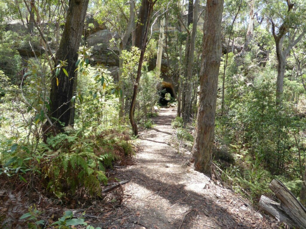
This up-and-back rail trail starts as a smooth asphalt path suitable for a wide range of abilities but gets tougher above the site of the coal loading area at Kirkwood Pl, which was not part of the railway line.
Section Guides
Mt Kembla to Nebo coal handling site (2km)
- Access: There’s on-street parking on the southern side of Cordeaux Rd, which is off the Princes Hwy. The shared path starts on the opposite side (Search: 200 Cordeaux Rd, Mt Kembla)
- Proceed uphill, with the remains of the track bed on your left for a short distance
- It’s then a pleasant walk through landscaped gardens beside American Creek
- The railway line on the right goes to the current coal loading facility in Kamira Valley
- After about 700m, at the Mt Kembla Mining Memorial on Stones Rd, there’s another car park where you can retire gracefully
- Your second chance of escape is at Kirkwood Place, which has a car turning area
- The top section is suitable for determined walkers and keen mountain bike riders only, who also have several downhill tracks through the area
- It ends at the site of Nebo Colliery’s coal handling plant, from where a conveyor belt carried the coal down to the train loading facility at what is now Kirkwood Place
- Take care coming down and watch for mountain bike riders coming across on their fast, downhill tracks.
![There's limited parking at the trailhead [2025]](jpg/n13-050-mt-kembla-theres-not-much-parking-at-the-trailhead-2025-img_6200-300x225.jpg)
There's limited parking at the trailhead [2025]
![The bottom section of the path has been squeezed in next to the railway [2025]](jpg/n13-051-the-bottom-end-of-the-trail-has-been-squeezed-next-to-railway-line-2025-img_6201-300x225.jpg)
The bottom section of the path has been squeezed in next to the railway [2025]
![A short section of the railbed retained for your viewing pleasure [2025]](jpg/n13-052-a-short-section-of-the-railbed-has-been-retained-2025-img_6205-1-300x225.jpg)
A short section of the railbed retained for your viewing pleasure [2025]
![Coal sculpture next to the line to Kemira Valley Loading Facility [2025]](jpg/n13-054-coal-sculpture-with-the-current-coal-line-in-the-background-2025-img_6207-300x225.jpg)
Coal sculpture next to the line to Kemira Valley Loading Facility [2025]
![View from the Bradford Breaker site with Port Kembla on right [2025]](jpg/n13-100-view-from-the-bradford-breaker-site-with-the-port-kembla-coal-handling-facility-in-background-2025-dsc00136-300x213.jpg)
View from the Bradford Breaker site with Port Kembla on right [2025]
Do you know of a bike hire or transportation service on this rail trail that should appear here? If so, let us know at admin@railtrails.org.au.
Information and Links
For more information:
https://www.illawarramercury.com.au/story/4235145/new-walking-trail-takes-in-mt-kemblas-history/
The trail is managed by Wollongong City Council https://www.wollongong.nsw.gov.au/
Contact Rail Trails Australia
To contact us about this rail trail, email nsw@railtrails.org.au
Background Information
Traditional Owners
We acknowledge the Dharawal people, the traditional custodians of the land and waterways on which the trail is built.
Development and future of the rail trail
The pathway was completed in stages, with the top section to the Bradford Breaker site completed in October, 2016.
Nearby Trails
Box Vale Tk rail trail
Southern Highlands, 110km south-west of Sydney
4 km


Como Bridge
20 km south of Sydney
2 km


Parramatta to Liverpool rail trail
Western Sydney, 25km west of CBD
16 km
Pippita Rail Trail
19km west of Sydney, near Sydney Olympic Park

Cooks to Cove Greenway
Sydney
6 km
Goods Line
2km from Sydney GPO
1 km
Meadowbank Railway Bridge
15 km west of Sydney
0.5 km
Rosehill to Carlingford rail trail
Western Sydney, 23km west of CBD
5 km
Lavender Bay “High Line”
Milsons Point to Waverton
Lapstone Zig Zag rail trail
Lower Blue Mountains, 60 km west of Sydney
1.5 km
Goulburn to Crookwell Rail Trail
195km southwest of Sydney, in the Southern Tablelands
Nearby Trails
Box Vale Tk rail trail
Southern Highlands, 110km south-west of Sydney
4 km
Como Bridge
20 km south of Sydney
2 km
Parramatta to Liverpool rail trail
Western Sydney, 25km west of CBD
16 km
Pippita Rail Trail
19km west of Sydney, near Sydney Olympic Park
Cooks to Cove Greenway
Sydney
6 km
Goods Line
2km from Sydney GPO
1 km
Meadowbank Railway Bridge
15 km west of Sydney
0.5 km
Rosehill to Carlingford rail trail
Western Sydney, 23km west of CBD
5 km
Lavender Bay “High Line”
Milsons Point to Waverton
Lapstone Zig Zag rail trail
Lower Blue Mountains, 60 km west of Sydney
1.5 km
Goulburn to Crookwell Rail Trail
195km southwest of Sydney, in the Southern Tablelands
One review of “Mt Kembla Memorial Pathway rail trail”
38/70 Interesting little trail, but a coffee van has taken over the parking area at the bottom. The top part seems to have been an access road at some stage and is not suitable for cycling or walkers with mobility issues. There does seem to be several mountain bike tracks in the area but they're for riding downhill.