 Location:
 Length:
 Surface:
 Start / End:
 Suitable for:
The Buderim Heritage Tramway rail trail is a well-maintained, 2 km path in the Buderim region of the Sunshine Coast. The general standard of the trail is good, but care must be taken in wet weather.
- It’s just a short walk from the centre of Buderim and the Bruce Hwy
- You can admire the regeneration of the bush in the tramway corridor
- It’s on the Sunshine Coast
Nearby Attractions
- Maroochydore beaches
- Buderim Forest Park
- Maroochy Regional Bushland Botanic Garden
- The Big Pineapple
Last updated: 29 July 2025
This pathway follows an old, narrow-gauge tramway through bushland. It has a crushed gravel surface and is usually tackled as a down and back trip. The trail is only suitable for walkers but personal mobility vehicles could tackle the first 800m from the service road to the left of the top entrance.
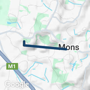
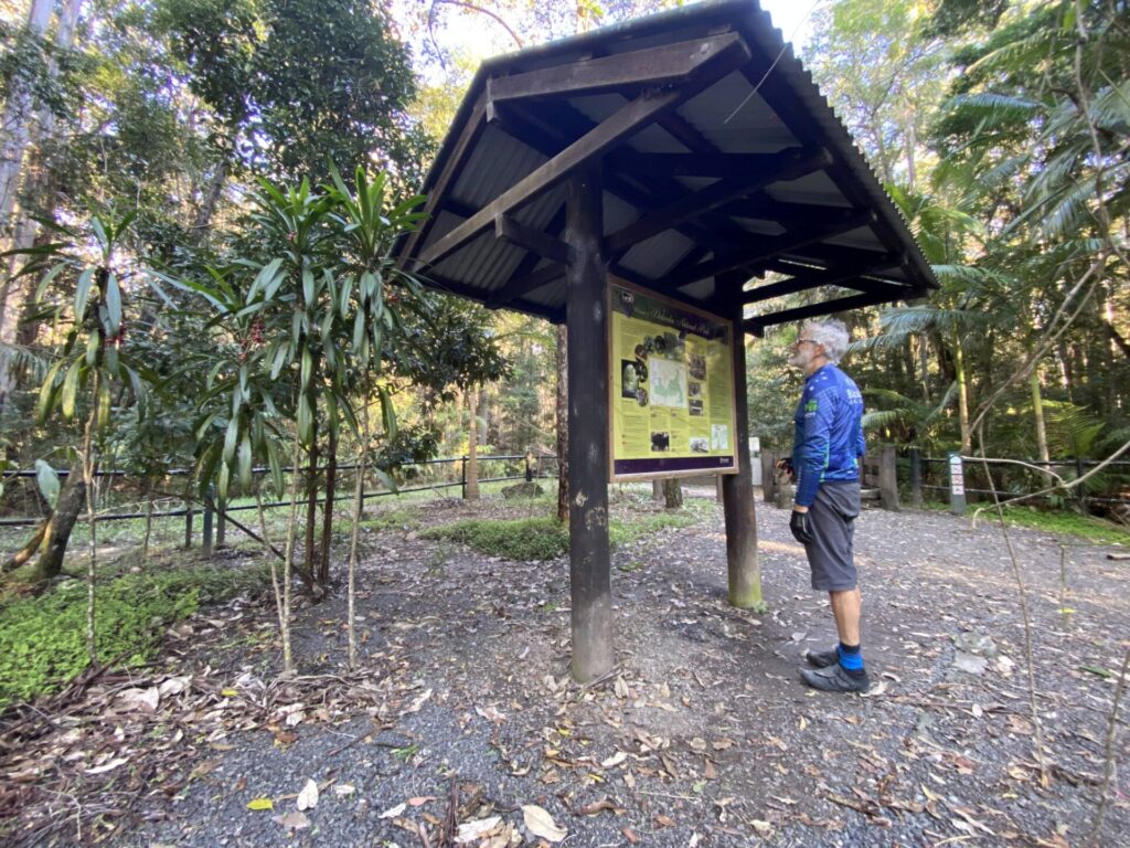
Access to this trail is near the corner of Mons and Telco roads in Buderim, 2 km west of the town centre. There is parking on the eastern side of Telco Rd, opposite the trailhead. A zig zag path leads down to an information shelter and the tramway corridor, which was filled in at Telco Rd.
There is no water or toilets here or at the Telco Station site about 100 m east on Mons Rd. From the shelter it is 1100m down to the Mons Station site through a profusion of forest plants and trees. Watch for a few railway sleepers that have been left in place, major cuttings and the elaborate stormwater drains built from rocks for the tramway.
The trail continues 1 km down to Liana Place, Forest Glen, where there is a profusion of retirement housing. This is the current end of the path and away from the tramway route, which continued to Palmwoods Station, which is still in operation. There’s minimal parking and no signage.
![Heading through one of the cuttings on the resurfaced trail [2025]](jpg/q12-130-tramway-cutting-near-mons-station-site-2025-img_6587-1-300x225.jpg)
Heading through one of the cuttings on the resurfaced trail [2025]
Top end of the tramway walk on Telco Rd, Buderim
![The elaborate zig zag down to the railway corridor [2025]](jpg/q12-150-serious-zig-zag-to-get-down-to-the-tramway-trail-from-telco-rd-2025-img_6592-225x300.jpg)
The elaborate zig zag down to the railway corridor [2025]
![From the information shelter, you come to this bridge over a stormwater channel [2025]](jpg/q12-140-bridge-over-xxx-stream-with-information-shelter-in-background-2025-img_6589-225x300.jpg)
From the information shelter, you come to this bridge over a stormwater channel [2025]
A resting spot in the sun at Mons Station site
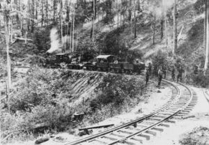
Track crew on the job on a horseshoe bend in 1915
![Lots of shade and rainwater have brought the forest back to life [2025]](jpg/q12-120-ferns-in-profusion-along-the-track-2025-img_6588-1-225x300.jpg)
Lots of shade and rainwater have brought the forest back to life [2025]
![Track crews had to build rock channels for the ample stormwater [2025]](jpg/q12-110-elaborate-original-stonework-to-keep-the-stormwater-under-control-2025-img_6584-225x300.jpg)
Track crews had to build rock channels for the ample stormwater [2025]
The tramway is accessible from Palmwoods Station, on Translink’s Sunshine Coast Line, by walking via Chevallum Rd and Sawreys Rd to Liana Place for an up-and-down adventure.
Do you know of a bike hire or transportation service on this rail trail that should appear here? If so, let us know at admin@railtrails.org.au.
Information and Links
For more information about this trail, click here
Contact Rail Trails Australia
To contact us about this rail trail, email qld@railtrails.org.au
Background Information
Traditional Owners
We acknowledge the Gubbi Gubbi people, the traditional custodians of the land and waterways on which the rail trail is built.
Railway History
This tramway was built to a narrow gauge (2’6″) to suit the terrain and left the Sunshine Coast Line at Palmwoods Station. Stations along this branch line were Chevallum, Forest Glen, Mons , Telco, Glenmount and Buderim, where there was a siding with a crane.
The first train ran on 1 December, 1914 and the line was officially opened on the 15 June, 1915. It closed on 10 August, 1935.
No part of the original line remains, but there are some sleepers visible on the walking trail. Part of the Translink line that runs behind Palmwoods Station is known as the Buderim Loop.
Come and enjoy the Buderim Tramway Centenary June 20 (S.E. QLD)
Posted: 05/06/15
Buderim-Palmwoods Heritage Tramway walk will be celebrating their Centenary on 20 June 2015. Celebrations will include unveiling ...
More...Nearby Trails
Dularcha National Park Rail Trail
Landsborough, 77 km north of Brisbane
3 km


Caboolture – Wamuran & Loop Rail Trail
Moreton Bay, 47 km north of Brisbane
10.5 km


Mary Valley Rail Trail
Mary Valley region, 158 km north of Brisbane (via Caboolture)
5 km

Ferny Grove Rail Trail
Samford Valley, 16km north-west of Brisbane
11 km
Brisbane Valley Rail Trail
Ipswich, 46km south-west of Brisbane
161 km
Brassall Bikeway rail trail
Ipswich, 41 km west of Brisbane
3.5 km
Kilkivan – Kingaroy Rail Trail
225km north-west of Brisbane
89 km
Nearby Trails
Dularcha National Park Rail Trail
Landsborough, 77 km north of Brisbane
3 km
Caboolture – Wamuran & Loop Rail Trail
Moreton Bay, 47 km north of Brisbane
10.5 km
Mary Valley Rail Trail
Mary Valley region, 158 km north of Brisbane (via Caboolture)
5 km
Ferny Grove Rail Trail
Samford Valley, 16km north-west of Brisbane
11 km
Brisbane Valley Rail Trail
Ipswich, 46km south-west of Brisbane
161 km
Brassall Bikeway rail trail
Ipswich, 41 km west of Brisbane
3.5 km
Kilkivan – Kingaroy Rail Trail
225km north-west of Brisbane
89 km
2 reviews of “Buderim Heritage Tramway Trail”
52/70 Nice little walk but ends rather abruptly at the bottom. Regrowth of the bush is a credit to the volunteers. Plenty of places to sit down, water fountain at the trailhead.
Delightful walk. Trail is in good condition, although a little boggy in places after rain.