 Location:
 Length:
 Surface:
 Start / End:
 Suitable for:
- The railway line from near Gladstone to Gayndah was 301 km so this could become Australia’s longest rail trail
- Much of the work to date has been done by volunteers
- The more people come to admire their work, the more likely the government will kick in extra money
- There’s camping along the rail trail and top pubs
- This is a great one for MTB riders and cyclocross fans who like a challenge
- There’s a shuttle service for the less enthusiastic
Nearby Attractions
- Heritage railway bridges
- Heritage railway station precincts at Gayndah, Mundubbera and Monto
- McConnell Lookout, Mt Gayndah
- Burnett River
- Camping and accommodation options in towns along the trail and in Kalpowar State Forest
- Glassford Creek Copper Mine, Kroombit Tops, Bulburin National Park
- Gayndah and Mundubbera are the state’s citrus capitals
- Reginald Murray Williams Australian Bush Learning Centre
- Boynedale Bush Camp
- Bundaberg to Gin Gin Rail Trail
Last updated: 18 December 2025
This trail through the Boyne Valley and over Dawes Range to the Burnett River is not for everyone. No concrete, no smooth asphalt but some beautiful landscapes and jaw-dropping railway engineering.
It is being developed in stages, with four sections open:
Dawes Range (25km): Offers stunning mountain views as it passes through six tunnels, with an array of national parks nearby.
Mundubbera to Mt Debateable (30.5km): Follows the Burnett River most of the way, has great views of some beautiful heritage bridges, with opportunities for canoeing.
Mt Debateable to Reids Creek (7km): A short trip on a variable surface to inspect the broken bridge across the creek.
Four-Mile Scrub to Boynedale Bush Camp (4km): Pleasant journey along the shore of Lake Awoonga.
Gayndah is the closest town to the southern end of the trail and has most facilities, including free camping at the former railway station. Along the way, there is parking at the railway sidings, with water and toilets available in most small towns along the corridor, see SECTION GUIDES
Section Guides
Dawes Range – Barrimoon Siding to Builyan (25km)
- Firm gravel surface to tunnels, softer gravel and sand in some sections after that, suitable for mountain bikes.
- Cattle on corridor
- No mobile phone service: UHF can be used in the area
- Carry plenty of water
- Most bridges are intact, but are not trafficable at this stage, so waterways may be impassable after rain.
Barrimoon Siding is about 6km from Kalpowar. Currently there are corflute rail trail signs placed at strategic positions from Monto to Barimoon Siding. (Note: It is a gravel road from Kalpowar to Many Peaks and is not suitable for caravans due to a steep descent.)
The first 10km of the trail descends via sweeping curves through the six tunnels and many impressive cuttings, delivering panoramic views of the countryside.
Once descended into the valley, the trail surface becomes less firm with some soft and sandy sections, gates to be opened and steep and loose gullies to be negotiated under existing rail bridges. The gullies are manageable when dry but will likely be impassable if water flows during or after rainfall events. All but one gates are straightforward to manage.
Approaching Many Peaks there is a signed detour to get trail users around a disused railway bridge. The signage is a little vague. There is a new amenity block at the historic Many Peaks Railway Dam but that is not on the rail trail. You need to get on to the (very low traffic) bitumen road at Many Peaks and ride back less than a kilometre to the dam park. It is well worth doing so as there is a shelter, history information signage, toilet block and elevated lookout over the old weir. There is no drinking water available.
The final section to Builyan Siding has more soft sections.
Facilities
- Kalpowar is a very small village with limited accommodation and facilities, and is 6km before Barrimoon Siding
- 2km before Barrimoon Siding is the Kalpowar State Forest camping area with a toilet
- Many Peaks has facilities at Railway Dam
- The Grand Hotel Many Peaks offers accommodation and meals Wednesday to Monday (closed Tuesdays)
- Builyan is a small village with limited facilities; a general store (not always open), and showers and toilets at the community hall
- The nearest major regional centre is Monto, so bring all required food and drink.
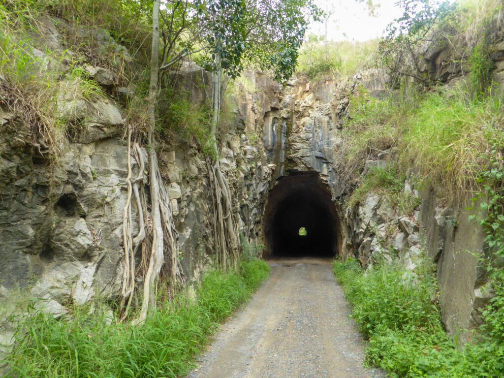
For those wanting more detail, the six tunnels were built just after World War I and their lengths are: No.1 – 100m, No.s 2 and 3 – 105m, No. 4 – 130m, No. 5 – 155m and No. 6 – 170m. Tunnel 6 still has the rail line and the original ‘hogback’ sleepers in place. One tunnel is significantly curved so that it is dark upon entering but after a short distance light starts to appear from the other end, so torches are not essential but may be helpful.
Mt Debateable to Mundubbera (30.5km)
The trail does not actually start in Gayndah, because of a destroyed bridge across Reid Creek. The access point is at the Mt Debateable Station site, which can be reached by using Gayndah – Mundubbera Rd and turning right onto Mt Debateable Rd about 10 km west of Gayndah. From here you ride west for a look at the rich variety of bridge designs used for the railway.
Mostly only suitable for fit mountain bikers, walkers and horse riders. Cyclists should be ready for puncture repairs. Expect significant soft sandy sections which will slow progress and some difficult gully crossings. There are plenty of gates especially towards Mundubberra.
- The trail surface varies from hard-packed railway ballast, to loose sand and soft mud
- Includes a remarkable number of heritage listed bridges. However none of the bridges are open at present, and temporary bypasses (some steep and rough) have been built around them.
- Close to the Burnett River, you get stunning views and koalas have been sighted in the eucalypt forest beside the trail.
- No toilets or drinking water along the trail
- Cattle on the corridor
This section was opened by the volunteer committee in September, 2022, at low cost to provide access for those keen to experience this picturesque section while funding is obtained to deck the many bridges and improve the trail surface.
Camping is available at Gayndah Railway Station and Mundubbera Showgrounds.
Mt Debateable to Reid Creek (7km)
Mostly only suitable for fit mountain bikers, walking and horse riding. Cyclists should be well prepared with provisions for puncture repair. Expect significant soft sandy sections which will slow progress and some difficult gully crossings.
It is only possible to reach Reid Creek by starting at Mt Debateable and going there and back. The trail follows the Burnett River towards Gayndah, and ends at Reid Creek where a large bridge was destroyed by a flood in 2013. Funding is being sought to build a replacement to get the trail into Gayndah.
Four-Mile Scrub to Boynedale Bush Camp (4km)
This walking only section runs from Four Mile Scrub to the popular Boynedale Bush Camp, along the shores of Lake Awoonga.
It has a smooth gravel surface and is basically flat.
![Gayndah Station site full of campers escaping a southern winter [2025]](jpg/q40-200-gaydah-station-site-full-of-campers-escaping-southern-winter-2025-img_6457-300x225.jpg)
Gayndah Station site full of campers escaping a southern winter [2025]
![Reid Creek Bridge was severely damaged by flood in 2013 [Mike Goebel]](jpg/q20-206-reids-crk-east-bank-banapan-2015-300x225.jpg)
Reid Creek Bridge was severely damaged by flood in 2013 [Mike Goebel]
![Riding from Reid Creek to Mt Debateable on a long embankment [2022]](jpg/q40-227-on-the-trail-between-mt-debateable-and-reids-creek-2022-09-300x225.jpg)
Riding from Reid Creek to Mt Debateable on a long embankment [2022]
![Orange markers go with the fruit at Mt Debateable Station site [2025]](jpg/q40-225-mt-debateable-station-site-cattle-grid.-orange-is-a-theme-2025-img_6476-300x225.jpg)
Orange markers go with the fruit at Mt Debateable Station site [2025]
![Trail between Humphery and Mt Debateable beside the Burnett River [2023]](jpg/q40-225-burnett-river-mt-debateable-to-humphery-20230310_090556-300x169.jpg)
Trail between Humphery and Mt Debateable beside the Burnett River [2023]
![The great scenery near Humphery on the way to Mundubbera [2022]](jpg/q40-227-20220222_nice-part-of-the-trail-between-mt-debateable-and-humphery-2_crop0-300x170.jpg)
The great scenery near Humphery on the way to Mundubbera [2022]
![Humphery No. 2, one of many bridges between Gayndah and Munduberra [2020]](jpg/q40-256-humphery-no-2-bridge-faith-aerial-2020-06-300x225.jpg)
Humphery No. 2, one of many bridges between Gayndah and Munduberra [2020]
![Funding to repairs is being sought so low-level crossings are required [2022]](jpg/q40-258-p1080582-boomerang-bridge-2022-09-300x225.jpg)
Funding to repairs is being sought so low-level crossings are required [2022]
![The Slab Creek Bridge being re-decked and fenced [Goebel 2025]](jpg/q40-250-slab-creek-bridge-2025-03-inspection-300x169.jpg)
The Slab Creek Bridge being re-decked and fenced [Goebel 2025]
![Happy rider on completed bridge near Mundubbera [Goebel 2025]](jpg/q40-250-slab-creek-bridge-2025-03-happy-rider_crop-300x244.jpg)
Happy rider on completed bridge near Mundubbera [Goebel 2025]
![Philpott Creek Bridge looking rather sad before its restoration [2023]](jpg/q40-256-philpott-creek-towards-burnett-river-300x225.jpg)
Philpott Creek Bridge looking rather sad before its restoration [2023]
![Decking and fencing that bridge removed a 4 km diversion [Goebel 2025]](jpg/q40-250-philpott-creek-bridge-2025-03-w-approach-plinth-300x169.jpg)
Decking and fencing that bridge removed a 4 km diversion [Goebel 2025]
![Mundubbera Station site retains many buildings [Goebel 2015]](jpg/q20-305-2015-entry-mundubbera-station-300x225.jpg)
Mundubbera Station site retains many buildings [Goebel 2015]
![The goods shed, station and a length of track remain at Eidsvold [2018]](jpg/q20-355-eidsvold-2018-09-0140-300x169.jpg)
The goods shed, station and a length of track remain at Eidsvold [2018]
![Monto Station, which is used for short stays by caravans and RVs [2018]](jpg/q20-405-monto-2018-09-0156-300x169.jpg)
Monto Station, which is used for short stays by caravans and RVs [2018]
![Monto has many of the charms of a Queensland regional centre [2018]](jpg/q20-405-monto-2018-09-0169-300x169.jpg)
Monto has many of the charms of a Queensland regional centre [2018]
![Typical scenery between Monto and Kalpowar [2018]](jpg/q20-455-bancroft-to-kalpowar-2018-09-0181-300x169.jpg)
Typical scenery between Monto and Kalpowar [2018]
![At Tunnel No. 6, volunteers retained track and unusual sleepers [2022]](jpg/q20-506-tunnel-6-2021-225x300.jpg)
At Tunnel No. 6, volunteers retained track and unusual sleepers [2022]
![View near top of Dawes Range, between tunnels [Gladstone Region Tours 2022]](jpg/q40-508-tunnel-4-to-3-dawes-range-lookout-2022-10-300x169.jpg)
View near top of Dawes Range, between tunnels [Gladstone Region Tours 2022]
![Tunnel No. 3 is another semi-elliptical design built from concrete [2021]](jpg/q20-506-tunnel-3-2021-300x220.jpg)
Tunnel No. 3 is another semi-elliptical design built from concrete [2021]
![Having a break on Dawes Range to enjoy a big embankment [2023]](jpg/q40-507-tunnels-to-golembil-2023-03-09_163452-300x169.jpg)
Having a break on Dawes Range to enjoy a big embankment [2023]
![A gully of marvellous grass trees at the bottom of the range [2023]](jpg/q40-507-grass-tree-gully-2023-03-09_162847-300x169.jpg)
A gully of marvellous grass trees at the bottom of the range [2023]
![Glassford Ck Bridge at Golembil. There is a low-level diversion [2021]](jpg/q20-556-glassford-ck-bridge-golembil-2021-300x169.jpg)
Glassford Ck Bridge at Golembil. There is a low-level diversion [2021]
![After descending the range, typical scenery at Coppermine Creek Bridge [2018]](jpg/q20-555-many-peaks-to-golembil-2018-09-0225-coppermine-creek-bridge-300x169.jpg)
After descending the range, typical scenery at Coppermine Creek Bridge [2018]
![Grand Hotel Many Peaks is an oasis before or after the Dawes Range [2025]](jpg/q40-600-grand-hotel-many-peaks-2025-img_6525-300x225.jpg)
Grand Hotel Many Peaks is an oasis before or after the Dawes Range [2025]
![New signs and fencing at the southern end of Boynedale section [2025]](jpg/q40-750-new-signs-and-fencing-at-the-southern-end-of-boynedale-section-2025-img_6532-225x300.jpg)
New signs and fencing at the southern end of Boynedale section [2025]
![Near Boynedale, trail skirts Lake Awoonga, as the line had to be relocated [2018]](jpg/q20-705-boynedale-2018-09-0261-300x169.jpg)
Near Boynedale, trail skirts Lake Awoonga, as the line had to be relocated [2018]
A shuttle service is available on the tunnels section of this rail trail. Packs and Pedals is a small company based at Monto, and offers limited shuttles and tours.
Do you know of a bike hire or transportation service on this rail trail that should appear here? If so, let us know at admin@railtrails.org.au.
Information and Links
For further information about the condition and maintenance of the rail trail, please contact the following:
- Burnett River Bridges section (Gayndah to Mundubbera): Mike Goebel on 0429 108 348 or email mi**********@***il.com
- Dawes Range section (Barrimoon to Builyan): Mark McLachlan on 07 4974 1207 or email mc************@***il.com
Some useful links:
Boyne Burnet Inland Rail Trail
Boyne Burnet Inland Rail Trail Facebook page
Parks of Boyne Valley and surrounds map
RM Williams Australian Bush Learning Centre and Visitor Information
Contact Rail Trails Australia
To contact us about this rail trail, email qld@railtrails.org.au
Background Information
Traditional Owners
We acknowledge the Wuli Wuli and Gureng Gureng people, the traditional custodians of the land and waterways on which the rail trail is situated.
Rail Trail Development
In 2012, after Queensland Rail confirmed the line from Gayndah to Taragoola would be closed, several community groups from towns along the line from Gladstone south to Maryborough held discussions with the Queensland Government about the future of the corridor. Each district had its own aims and ambitions, ranging from preserving the tracks as a working railway to developing the corridor as a recreational trail to showcase the old infrastructure while creating a rail trail to attract tourists.
In 2019 a feasibility report was released recommending construction of three sections of rail trail;
- 36 km along Lake Awoonga
- 32 km Dawes Range from Builyan to Kalpowar
- 29 km Burnett River Bridges from near Gayndah to Mundubberra.
The Boyne Burnett Inland Rail Trail organisation quickly swung into action and opened a 26 km Dawes Range section from Builyan to Barrimoon Siding in September, 2021, with a minimum of development to get usage going. They would like to extend this the other 6 km from Barrimoon to Kalpowar.
The Bridges section opened in 2022, with diversions around some bridges.
The Boynedale section was opened in 2023 by the Gladstone Area Water Board.
Railway history
In the 1880s Queensland Railways started constructing an inland loop from Mungar (near Maryborough) north to Calliope (near Gladstone), 420 km via Monto. The first section, from Mungar, opened in 1889 and the last, from Monto to Calliope, in 1931.
A feature of the line was the varied designs of the bridges, particularly in the Gayndah area. The last regular train ran in 2002 and the very last, a steam special, in 2008.
A 126 km section from Mungar to Gayndah still has tracks in place for possible heritage trains, so the rail trail could be around 300 km long.
QLD Invests $3.5 Million to Upgrade 4 Rail Trails
Posted: 27/09/25
The Queensland Government announced in September 2025 that it will spend $3.5 million on 4 regional rail trails. ...
More...Boyne Burnett Inland Rail Trail weekend a great success
Posted: 14/05/24
Between 3-6 May, Bicycle Queensland partnered with the Boyne Burnett Inland Rail Trail Association to ...
More...Boyne Burnett Inland Rail Trail Weekend
Posted: 20/01/24
A great weekend is being offered early in May --- spend the weekend on the ...
More...Another step closer to becoming Australia’s longest rail trail for Boyne Burnett Inland Rail Trail
Posted: 08/10/23
Construction of Australia’s soon to be longest rail trail has recently gained momentum, with ...
More...Celebrations for opening of Four Mile Scrub to Boynedale Bush Camp Rail Trail
Posted: 30/06/23
Gladstone Area Water Board (GAWB) celebrated the opening of its new $970,000 Four Mile Scrub to ...
More...Burnett River Bridges Rail Trail Open
Posted: 28/09/22
Under sunny skies the Burnett River Bridges section of the Boyne Burnett Inland Rail Trail (...
More...Opening of the Burnett River Bridges section of the Boyne Burnett Inland Rail Trail
Posted: 10/07/22
The Boyne Burnett Inland Rail Trail committee invites you to the opening of the Burnett ...
More...Boyne Burnett Rail Trail – Opening the Dawes Range Section
Posted: 03/10/21
The opening of the Dawes Range section of the Boyne Burnett Inland Rail Trail in ...
More...Boyne Burnett Inland Rail Trail Report Released
Posted: 23/05/19
The Boyne Burnett Inland Rail Trail would provide a link between Taragoola, near Gladstone, south ...
More...Nearby Trails
Boolboonda Tunnel Heritage Trail
Bundaberg region, 400 km north-west of Brisbane
3 km


Bundaberg to Gin Gin Rail Trail
Bundaberg region, 365 km north-west of Brisbane
4.4 km

Nearby Trails
Boolboonda Tunnel Heritage Trail
Bundaberg region, 400 km north-west of Brisbane
3 km
Bundaberg to Gin Gin Rail Trail
Bundaberg region, 365 km north-west of Brisbane
4.4 km
18 reviews of “Boyne Burnett Inland Rail Trail”
Hello,
Does anyone know if the Monto to Mulgildie section has been completed yet and is open to ride?
thanks in advance
Cheers,
Marty
Just loved this track with all the tunnels and amazing views. Stayed at Kalpowar State Forest but it was very busy. Would stay at Golembil Siding next time. The views from the campsite were lovely (the pictures don't do it justice).
We take our hats off to the volunteers who have developed an amazing trail. In time we will ride the entire 270kms end to end when it’s finished .
This visit Our group camped in self contained RVs at Golembil siding to ride up to Barrimoon return one day. Then Golembil to Many peaks fabulous Grand hotel for meals and return.
Then move camp to Ubobo for the same.
We found out about the great hotel accommodation option at the Grand Hotel at Many Peaks too. Great trail.
Riding from Gladstone the tunnels and the views from there are amazing and always a highlight for me. Monto Gayndah and other friendly country towns along the way give you a taste of country Queensland. Packs-n-pedals where there when I sought a lift on a strong wind day.
48/70 This is an "adventure" trail and not for everyone, but the major storm damage seems to have been fixed up. The cattle produce a nice clean line where they are in the rail corridor but there are still plenty of loose rocks around. The shuttle service seems to take people to Barrimoon Siding for the downhill run through the tunnels and that's definitely the highlight. There's disabled access to Tunnel 6 and new facilities at the siding. I rode the Bridges section return the first day, then the tunnels section from Barrimoon the second day and then walked some of the Boynedale section from Gladstone-Monto Rd, although I can't see why you're not allowed to ride it. Camped at Gayndah Station site and Grand Hotel Many Peaks. The precipitous road down from Dawes Range gives you some idea of what they achieved with the railway. No trucks or caravans allowed! One memorial in place to show you why
I rode the Mt Debateable to Reids Creek section on the 12th of June 2025. Congrats to the committee and volunteers for the prep and upkeep of this trail section. Keep up the good work.vI met a couple of volunteers on the trail as they were doing more slashing (thanks). This is a great little end to the trail down to Reids Creek Bridge (where some of the structure was washed away during flooding). It is quite scenic with varied surface conditions but very rideable and enjoyable with views of the river in places.
I was told that "one day" there maybe a link at the Reids Creek Bridge location which would take the trail into Gayndah.
Hello,
I rode the Mt Debateable to Mundubbera section on the 11th of June 2025. Congrats to the committee and volunteers for the prep and upkeep of this trail section. Keep up the good work. The trail is pretty well marked with orange coloured posts and gates and bike signs along the way. I used the fantastic services of Packs n Pedals to pick me up at Mundubbera and drop me off at Mt Debateable so I could ride back to Mundubbera. Great ride with the river in sight some of the way. A couple of bypasses around some old bridges but all doable. Overall, great ride.
Hello,
I rode the Dawes Range Section on the 10th of June 2025. Congrats to the committee and volunteers for the prep and upkeep of this trail section. Keep up the good work. The direction and information signage is fantastic. There are new toilets at Barrimoon and Golembil and there is camping at these locations too. I parked at Builyan (Boyne Valley) and used the fantastic services of Packs n Pedals to pick me up and transfer me to Barrimoon Siding to then commence the Tunnel Section etc. Great ride (down the hill) to Builyan with the 6 tunnels etc. If you have time, stop in at the Grand Hotel at Many Peaks as the trail runs right past the back (except on Tuesday's when they are closed). At Builyan Hall, there are toilets at the rear and also a shower that takes $1 coins (only). Overall, great ride.
Bridges Section: Philpott Bridge to Humphrey Siding
This section has seven railway bridges including the Humphrey No. 2 bridge, which is the most interesting bridge as it is a concrete arch viaduct bridge that is still serviceable with passage over the top. The other bridges are all interesting variations of timber, concrete pier and steel trestle. The gullies around these bridges are easier to negotiate than the Philpott bridge gully but are still challenging to less confident off road riders. There is a display in the railway station at Mundubberra that provides information about each of the bridges although I found the sequence of bridges to be different to what was indicated in the information display. Difficult to know for sure as none of the bridges have names on them when you get to one.
Generally, the trail is reasonably okay to cycle but the stones are flinty and sharp. We had two punctures within our group of four riders. A local farmer happened upon us as we were repairing one flat and he said the last pair of cyclists he spoke to also had issues with punctures. Be prepared for flats! From Boomerang Siding to Humphrey Siding there is a well formed gravel road running parallel to the trail and close by the Burdekin River. It is much easier to ride than the rail trail and provides better views of the river. We chose to ride the trail one way then return by the gravel road. This is a scenic ride but not an easy ride.
Bridges Section: Philpott Bridge to Mundubbera.
This section should only be attempted by competent off road cyclists with mountain bikes, preferable full suspension.
This has very scenic sections near the Burnett River and more open pastoral country heading into Mundubbera. The gully crossing under the bridge is challenging being both steep and rough. After rain it would be impassable. The trail itself is a hard slog with many sections of rocky ballast and soft, coarse sand and rock. Some sections have a rough trail off to one side as the formation itself is just too soft. I punctured after my near new MTB rear tyre developed a 5mm slit in the carcass of the tyre and the tube became exposed. I averaged 10km/hr (moving time) over this section. (I am an experienced mountain biker/ adventure touring cyclist with a full suspension ebike.) There is a diversion on what appears to be a four wheel drive stock route around one closed section of the corridor which has a bolted shut gate.This is not apparent until you proceed along the corridor some distance. The diversion has multiple gates to negotiate but they are all new gates, easy to open and close. There are signs but best to use the RTA map to guide you around.
The Mundubbera Railway Station is now a small historical museum with loads of information. There is a good bakery cafe in the town for coffee and food. This is definitely an adventure trail.
We asked locals including the tourist information centre for information about the trail. No help. Eventually we found the details on this page. Even then, as we’re not locals, it took some time to find the trail head.
At the trail head you can go east to the 7 klm section to reids or west to mundubbera. Loved the humor of the sign writer at trail head. . Overall a good track that in time will attract a LOT of bike, walking and horse traffic. The volunteers have done a wonderful job. Some signage was challenging. We chose to ride about 10klms towards Mundubbera from trail head and return. Lots to see and the range of bridges is neat. Top effort to all volunteers. If promoted to Brisbane Valley Rail Trail pages, it would attract those wanting the challenges that the current trail offers.
This was the first of the rail trails that my wife and I have attempted and it certainly won’t be our last. We left home in Bundaberg at lunchtime, arriving at Kalpowar State Forest campground by mid afternoon. The weather wasn’t the best, overcast with some fine rain around, but we decided to get the bikes off the rack and hit the trail just to have a look, as our plan was to complete the whole trail, there and back, the following day. We ride full suspension Electric mountain bikes, and although the signs were quite clear, we did actually miss the entrance to the trail, mistaking the gateway for a private property. We ended up on very steep muddy roads which were really quite challenging even on an ebike, eventually turning round and going back to camp. I have a BLUETTI battery bank in the campervan, so was able to clean the bikes and put them on charge so we could tackle the trail again the following day. Having taken the advice from a fellow camper, we found the trail and completed the track all the way to Builyan and back and absolutely loved it. There were several creek crossings that had flowing water, which allowed us to use our mountain bikes to their full potential. Range anxiety did come into play for my wife, as she used full assistance all the way from Kalpowar to Builyan, which was mostly downhill, so eco mode and trail mode were used coming back, and her battery finally gave up 50 meters from camp! This was a brilliant introduction to the rail trails, next on the list is the Gayndah to Mundubbera trail! Can’t wait!
Camped at Kalpowar State Forest and was easily signed 2km to trail start. Having read the conditions beforehan I was expecting it to be a bit rough. 2 of us on Gravel bikes quite manageable, rough dirt, crushed ballast and cow divets. Tunnels were great, dark, bring a head light!
Downhill to Builyan so up on the return but not difficult.
Some signage needs improving near Manypeaks and was easier to use the road to Builyan but found the trail on our return.
We had to walk through 2 creeks hence decided to use the road on our return to avoid one of these. Would be difficult or impassable in wet weather.
Once some bridges are built or stepping stones placed over the creeks it will be great but for now it's more an adventure.
Well done to all the volunteers.
A great trail
It's an enjoyable downhill ride, through 6 tunnels if you start at the Kalpowar end. With most of the gravel trail surface fine to cycle on, except for a few short sections which are overgrown with grass. Thankfully the tunnels make up for this, as there aren't many rail trail tunnels in Australia.
The first tunnel has rails still in it. I was initially concern each one would also have rails, but since it's only the first tunnel it's fine to walk through and adds to the charm of the trail.
Even when not in a tunnel the trail passes through some decent rail cuttings and in between tunnels and cuttings there are some nice hilly views over the edge.
Sadly the bridges on this trail aren't rideable yet so I had to take my shoes off to cross the main river crossing, while as I exit the hilly section and meet the main road the trail is less consistent with some short up and down sections, to get around bridges. However there are still some nice cuttings as the trail follows the reasonably quiet gravel road and a river.
At the moment the trail is only 25kms, hopefully it can be extended initially back to the small town of Kalpowar and eventually to the larger town of Monto, along with heading further up the valley towards Gladstone.
There is a nice railway mural on Kalpowar's Town Hall.
Once you can cycle across bridges, the surface improves and the trail is longer it will be one of the great rail trail rides in Australia because of those 6 tunnels.
What a memorable 24 hrs! Rode the rail trail, I have to say to my scenic rides of done , the steady inclined took us under some magical old bridges gained enough elevation to breathtaking veiws. Had some lunch and ended through the magnificently made tunnels. The day didnt finish the we had our squad meed at the end tunnels . We rode back to camp where the family easter celebIrations started , puppys , horses gifts chocolates alcohol and a feast , lasagne ,scollop potatoes salad and gourmet icecream for dessert. Woke up to hot cross buns coffee . Recommended ride and the trail is amazing well done to the volunteers that have made this possible. Loved it and camped at Kalpowar with the family. NOTE WE RODE UPTO KALPOWAR .
This trail has only been open a short time with the wonderful attraction of 6 tunnels and fantastic views. At this stage I would describe it as an "adventure" (rough)trail, but pure mountain bikers would probably love it. No bridges so many deep, rough creek crossings to get up and down. Reasonable surface with sections of rough and then soft surface. Be aware, particularly in hot weather, no phone service, water or food on this trail. The section with tunnels has become so popular local "Packs n Pedals" has started support tour of this section. With proposed future improvements this will be a trail worth visiting.
Three of us rode the BBIRT yesterday. We started out from Barrimoon and rode to Builyan and return, total distance of 52kms. There is a small shop at Builyan, but it wasn't open on the day we were there.
Overall we found the ride to be quite challenging, due to lush vegetation, rough surface and deep creek crossings.
The first part was all downhill through the six tunnels and large cuttings. Although the surface was quite good in this section, the grass on the trail was very thick in places and over our heads. There was also a lot of fallen rocks on the track through the cuttings. Once we were on the flatter section of the trail, we came across the many creek crossings. Some had intact bridges that are not used for the trail at this stage, and other crossings had no bridge in sight. Getting down and up some of these crossings proved to be quite challenging, especially where cattle had churned up the surface.
This trail is in its infancy, and has huge potential. The views at each bend in the top section are stunning. Once more money has been sourced, the surface can be improved, and the old bridges can be fitted with decking and railing. A logical place for the trailhead would be Kalpower, as it is easier to access by motor vehicle, and there is some accommodation available. I believe that it is part of the future plan to extend the trail by 5km from Barrimoon to Kalpowar.
A local Monto tour company is offering 11km twilight tours from Barrimoon that are proving to be very popular. Another case of "build it and they will come"
I have recently cycled the section from Barimoon Siding to Many Peaks. Currently there are temporary corflute rail trail signs placed at strategic positions from Monto to the high point over the ranges at Barimoon Siding. The first of six tunnels occurs within the first kilometre of the start of the trail and the remaining five tunnels appear within the next three kilometres. One tunnel is significantly curved so that as you enter it is dark but you proceed only a short distance before light starts to appear from the other end. So torches are not essential but may be helpful. The first ten kilometres of the trail descends via sweeping curves through the tunnels and many impressive cuttings, delivering panoramic views of the countryside. The trail surface is firm and the first two gates across the trail have ride over stock grids beside them.
Once you descend to the valley, the surface becomes less firm with some soft sections, gates to be opened and steep and loose gullies to be negotiated under existing rail bridges. The gullies are manageable when dry but will likely be impassable if water flows during or after rainfall events. All but one gates are straightforward to manage. The exception isn't actually a gate; it is a set of barb wire runs that are on star pickets spacers with a shortened star picket that is used as a lever to tension the fence/gate section closed. It is a bit of a handful.
Approaching Many Peaks there is a signed loop detour to get trail users around the disused railway bridge. The signage is a little vague. There is brand new toilet amenity block at the historic Many Peaks Railway Dam but that is not on the rail trail. You need to get on to the (very low traffic) bitumen road at Many Peaks and ride back less than a kilometre to the new park. It is well worth doing so as there is a new shelter shed, history information signage, toilet block and elevated lookout over the old weir. There is no drinking water available.
The final section to Buliyan Siding has more soft sections. Bring all your water and food and allow more time than you may think to ride the entire section especially if you are planning an out-and-back ride. This is a fantastic trail, challenging in places, still in its infancy as a rail trail.